
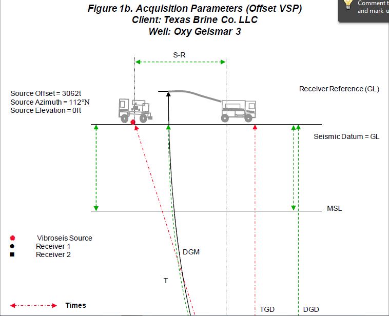
Baker Atlas conducted a Checkshot Survey and an Offset VSP Survey for Texas Brine Company Ltd. in the well Oxy Geismar 3, located in the Grand Bayou field, Assumption Parish, Louisiana. The objectives of the surveys were to:
Measure time-depth information
Image the salt flank
At the time of the survey, the well had been flushed to create a cavern below 3400ft. The surveys were performed in the borehole above this depth. A sketch of the well and possible salt location is shown as Figure 3. All measured depths are referenced to Ground Level. The well is considered vertical.
The survey began at 9:52 hrs on September 25, 2010 and was finished at 10:49 hrs on September 26th, 2010.
A vibrator source was used for the surveys. One vibrator was positioned 123 ft. from the wellhead at an azimuth of 77 degrees for the checkshot survey and then two vibrators were located 3062 ft. from wellhead at an azimuth of 112 degrees for the Offset VSP survey.
A 6204XB 3-component downhole receiver was used to record the survey.
This is how they perform a VSP.

and this is the final report regarding the Oxy 3 Cavern in 2010.


Take Note, the “B” line is the 3D Seismic Pick.
Any Questions?
The full Vertical Seismic Profile can be found at:
Oxy Geismar No 3 (180708) VSP 2-2011
This is the history of the salt cavern. Please take notice of when most were published by the Louisiana Dept. of Natural Resources. After the Stinkhole formed!
http://ucmwww.dnr.state.la.us/ucmsearch/FindDocuments.aspx?idx=xwellserialnumber&val=180708
Even earlier SONAR scans show the bottom 1000 ft. of the cavern was compromised as shown by the almost perfect straight line, demonstrating that section was pressed against the shale sheath at the time. It would be interesting to have the drawdown records of the dates after these SONAR surveys.
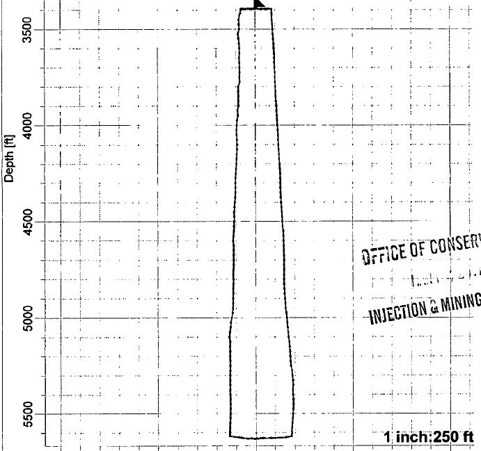
SONAR Survey of Cavern 10 /06/2007, Pages 49-50 (Notice the straight line deformation showing bottom of cavern pressing against the Shale Sheath, and the Horizontal Slices show even better detail of this)
Regardless, these surveys do constitute proof that LDNR and Texas Brine both were complicit in a cover up of the gravity of the situation, years prior to the August 3rd, 2012 failure of Oxy 3 Salt Cavern.
Now we know how Mr. Hecox could honestly say, “There has been a Frack Out of the cavern.”
“Frack Out” is a term used to describe an over-pressure of fluid that overwhelms the medium within which it operates, or a failure of the medium itself, due to invasive enviromental or man-made factors.
Now new information has come in from EMILY (Hat tip back at ya), over at flutrackers, showing beyond a shadow of a doubt that Hooker #8, (later Vulcan #3, then OXY #3), was sitting upon the shale sheath back in 1995. OXY#3 is the only cavern against the Sheath. It is the furthest westward cavern shown by it’s coordinates. Texas Brine continued to operate this cavern at a lesser capacity for 14 years, then plugged and abandoned it, until the pressures built to a point where it ‘fracked out’ and blew away the shale sheath that had held the bottom of the cavern in for so many years.

Source: Neal, J. T. and T.R. Magorian. April 1995. Geologic Site Characterization (GSC) Principles Derived from Storage and Mining Projects in Salt, With Application to Environmental Surety. SAND95-2400J. Sandia National Laboratories, Albuquerque, NM.
The credit will have to go to Sandia for having these documents available.  They will email you the articles you request from this list:
https://ugsprtech.sandia.gov/Pag_Reports/Bibliographies.aspx?c=2,4&g=Geotechnical
(You must have email client installed for Sandia to send this document.)
As for this 1995 paper, this speaks of Oxy 3, as is shown by coordinates of it being the westernmost cavern in the Salt Dome. The last 500 ft. at the time, showed the straight line deformation of where the cavern had been miscalculated and was now resting upon the shale sheath, which is all that held containment at the time.
<SONAR Survey and VSP shown above.>
What was not taken into account was two-fold, first Texas Brine did not take into account was the effects of drawdowns, as this would widen the area against the sheath that was bereft of salt. This finally left about the deepest 1000 ft. (4500-5500 ft.) of the cavern and the contents and pressures sitting on the actual shale sheath itself from the inside.
The second thing not taken into consideration was that salt creeps. When a cavern is filled it is under pressure, plus the weight of the overburden, and when it is drawndown then the salt creeps back in with the difference in temps and pressures. In a very real way, it can be stated a salt cavern functions similar to a lung. This is due to the plasticity of salt rock. Shale has no such elasticity. It can only take so much in the way of pressure, and then it fractures, just as a rib would do in the human body.
Now, add to this that Big Hum, Marg Vag and all the oil and gas and water formation sands were pressing from the outside of the Salt Dome and pinching up against the very same shale sheath that was dealing with the cavern pressures, in almost the exact same spots but from opposing sides. When this shale sheath finally fractured, it was a mighty geologic explosion 4500-5500 ft. down. Enough of one to fracture the shale and other materials all the way to the surface, and to 6500 ft. depth.
Every bit of this was known by LDNR and Texas Brine long before the mill out that failed the MIT test, and they Plugged and Abandoned Oxy #3.
If they had drawndown the cavern one last time and Cemented the bottom 1000 ft.. then pumped back the brine and P&A’d the cavern, then this probably would not have ever happened. Due to the costs, they chose not to. LDNR knew this as well, even about the oil sands pressing against the shale sheath and cavern, due to their accessibility to Golden Gate’s proprietary 3-D 2007 survey, that no one else has been allowed to see.
I wonder what Texas Brine thinks about the cost of that cementing job now?
NEW UPDATE! Now LDNR claims, as well as SANDIA LABS, that they were referring to OXY GEISMAR #1, in the 1995 paper that produced the graphic above. This is the NEXT MOST SHALLOW SALT DOME CAVERN in the NAPOLEONVILLE SALT DOME, and was created in 1976, SN# 151645 and was known to be sitting on a SHALE INTRUSION in the Salt Dome. It was drilled to a depth of 3200 ft, ceiling of 2500 ft.and then cemented up to support a Salt Cavern. SONAR surveys of 9/20/2012 show the true deformations, and the shallow wide volumes of this very shallow 750 ft. in height cavern, mined more horizontinally, than vertically.
Please use this map for location purposes:


The flat surface is the SHALE INTRUSION INTO THE SALT DOME, and please take note LDNR knew this, and permitted it still, knowing it lay at the edge of the Salt, and on SHALE!
Another Cavern bearing the Occidental name is another former Texas Brine Well #1 SN# 109979 and is just on the East side of Grand Bayou, (across from the Crosstex #1 Cavern with butane within), and is the most deformed Cavern at Napoleonville Salt Dome, and both appear to be setting upon Shale intrusions. Take note of the dogleg cemented at the bottom and the flat shale/salt rock it sits upon as well. Very confusing data……

Take Note of the Cement Wedge at the bottom, but there is more;

Even more:

This Well is currently undergoing a workover and was found to have an anomaly in the casing at 670 ft. This is just below the caprock where it enters the salt. Any anomoly could be indicative of salt rock movement, yet no details of this anomoly has been forthcoming. The flat bottom shown is the shale/salt rock, and the dogleg is the Cementing job. Texas Brine could find the money for cementing both these shallow and potentially dangerously hollow spaces on the edge and one definitely sitting upon the Shale, yet could not spare a dime to cement the bottom of Oxy #3, since it was no longer useful to their interests.
OXY GEISMAR # 1 is in danger of failure, (First two pictures shown above), due to the shallowness of it’s depths, and the width mined outwards at the top. If it is truly a brined out well at the end of its usefulness as of 2011, then why was it not plugged and abandoned?
Oxy Geismar BW#1 is being used for seismic surveying at this time, is wide open, and a geo-string has been inserted into its casing for the 3D seismic survey..
(DISCLAIMER: I am not an attorney and my opinions should not be construed as such. Please consult your own attorney for specifics on the value of the information contained within this article.)
IMHO, No more proof is needed, but of course we shall keep building a case. The resident’s and their lawyers can now make the call as to whether to proceed with actions against Texas Brine, and the State of Louisiana Dept. of Natural Resources for Willful Neglect and Harm, with Malice Aforethought, and a host of other criminal and civil charges.

Reblogged this on The Louisiana Sinkhole Bugle and commented:
They knew! And they knew about the rad waste too!
corruption is created by greed and evil. They do not care about anything but money. Hasnt Halliburton got their hands in this somewhere. That kind of money can do anything, I am so happy for the residents and i pray the suit is swift so they can get their money and babies and get the hell out of there before it is to late
I am sure most of them have Attorneys already, and a class action was already started, yet we never see the attorney field any questions at the meetings. With the evidence contained within the VSP, each and every resident now has the power to individually engage a lawsuit personally, and sue Texas Brine and the State if they want to leave, because neither is sincerely offering any other way out, except as penniless refugee’s.
Carol Bellinger
Halliburton– not really- they are not an oil company, Do not produce or use salt brine. Nothing but an oil field servoce company– Where did you get the Idea Halliburton would be involved–?
Thad, although I agree that Halliburton is a Service Company, the fact remains is that they have worked on nearly every part of that dome, and they provide all of the bentonite for all involved, and were integral in the Gulf South disaster in 2003, so it is not unreasonable for Carol to have reservations and suspicions whenever she mentions Halliburton.
Much worse than that, you are standing in an ‘Erin Brockovich’ moment. This is beyond explosive, because this involves Jindal directly, not just DNR, and guess what, his Attorney Quit!
http://www.nola.com/politics/index.ssf/2013/01/bobby_jindals_chief_lawyer_res.html
Yall just remember, while you are engrossed in the law suit and trials, dont forget to continue to keep up with what is still going on at the sink hole. Its easy to kill someone if they are asleep. Eyes wide open yall. No people, no payout, understand. Prayers are with you all
It just take one heck of a batch of looking, but this document did seem to have critical info. Glad you could see the problem– sometimes the looking does not find anything. JEC
Jec,
I have been a natural born researcher since I was 5 years old. I never saw myself that way…just wanted to know how things worked…
That being said, you and so many others are the very ones that give researchers the ideas that many times sends us in an entirely new direction.
Never belittle your or anyone’s contributions, because without the suggestions, theories, and open discourse…then researchers would quickly become stale and deal only with statistics.
Class action or TORT lawsuits can be deceiving. Consider the options and don’t let the lawyers walk with the monies you, as landowners and injured parties should get.
Do your research before deciding which course to take and even if you decide to go into individual lawsuits, don’t let them pit one against the other. Make a UNITED front as best your can.
Greed of Texas Brine and others can creep in on residents also and they will gain, and you will lose in the long run. You are very lucky to have someone like Freedomrox stay on top of this situation and have the knowledge and tools to seek out the info. 🙂
Maybe this will actually turn out to be a WIN ( even tho you lost your utopia ) for the people against Big Oil.
Tread slowly.
Very wise words indeed. Thanks for the visit and come back soon if TB or LDNR haven’t offed me by then. 😛
The following information was posted in answer to Emily over at FluTrackers. It gives good information about the only other known Cavern that actually sits upon shale from an incursion in 1987.
I believe I can answer your questions about Hooker #6, now Oxy #1. Back in 1987 Texas Brine sought to expand the solution mined cavern for larger storage capacity, but failed. They went down to 3000 ft. approximately, and hit shale rock, an intrusion. They then plugged off and cemented the bottom and proceeded to brine the cavern outwards more towards the top. This is the most deformed and shallowest of caverns as shown by the 1993 SONAR survey.
Click to access UCMRedir.aspx
Pingback: LDNR AND TEXAS BRINE KNEW – Article Updated with New Info | The Louisiana Sinkhole Bugle
OCCIDENTAL CHEMICAL CORPORATION OWNS THIS! STINKHOLE AND ALL! ALL OF IT, and not TEXAS BRINE!
Click to access 12.Emergency.Texas.Brine.pdf
Pingback: Louisiana Sinkhole: Answers are Forthcoming | freedomrox
Great NEW UPDATE on this article. Re-RE-posting 🙂
Pingback: Ireland: Get Ready for an UNDERWATER Stinkhole! Oxy 3 Manager, BP, Making Huge Cavern Under East Irish Sea! | The Louisiana Sinkhole Bugle
Actually Texas Brine and PB Energy. There’s two of them. I just updated it again…un-frickin-real!
great!
Tiny URL for this page is
http://tinyurl.com/cpaumua
Pingback: New Damning Evidence Texas Brine Should’ve Plugged Up Ol’ Barfy. | The Louisiana Sinkhole Bugle
Reblogged this on Heidi-Lore’s Musings and commented:
Bastards.
Pingback: Seismic Event at Lake FUBAR Overnight + Weekend News | The Louisiana Sinkhole Bugle
Pingback: Dear Blue Ribbons, | The Louisiana Sinkhole Bugle
Pingback: Really wanting to copy this info, it needs to be seen and not covered up. | My Blog