
(Special Thanks to On Wings Of Care, and Ms. Bonny, and the Power Hour)
I have avoided for a while giving my opinion and the opinion of many others, the light of day concerning how this geological nightmare in Assumption Parish, Louisiana, also known as the “Great Louisiana Sinkhole”, came into being on August 3, 2012..
I can no longer put this off as so many have sent emails asking for my humble opinion and compilation of the events that led up to the present situation. Please take into account this is not just my opinion alone, and that there is a reputable geologist, hydrologist, seismologist, and a salt rock mechanic, (geologist specializing in salt rock formations), that comprise the team that makes this blog possible. All are volunteers, and they are all greatly appreciated. Most are still engaged in their respective fields, and therefore cannot be named at this juncture, for fear of retaliation.
With that firmly stated, and acknowledged, then on with the explanation as we see it.
First we have Hooker Oil Well #1 that was drilled to a depth of 6,200 ft., which is why it was later named 6200 RA SUA , (HookerOilWell1 History). The well was first drilled and completed in 1986 down to the depleted formation shown in the 2007 3-D survey. It was drilled 338 ft. directionally in an southeastern direction for a Bottom Hole Location offset..
It changed hands a few times until Energy Self Service Oils, Baton Rouge, La. took it over in 2006 for Natural Gas, then sometime between then and Feb. 2008, (likely earlier, since its shown depleted in 2007 3D survey by Golden Gate), just up and walked off.
Orphaned without a word to anyone. The state had to come in and P&A the well themselves in 5/12/2010. This shows the actual effectiveness of the Dept. of Conservation, as it took them three (3) years, to figure out this well was orphaned and only because deer hunter’s complained about the oil leaking from the wellhead and rusting tanks left behind. This was an open well, and right next door to the Oxy #3 cavern and at the same depths. The depletion of this formation right next door to Oxy 3 and the salt dome may have had a role to play in all of this due to its proximity just underneath the Oxy #3 Cavern, and I intend to prove just how.
ERRORS: (Part I)
OIL WELL VS. SALT CAVERN EQUALS DISTRESSED SHALE SHEATH
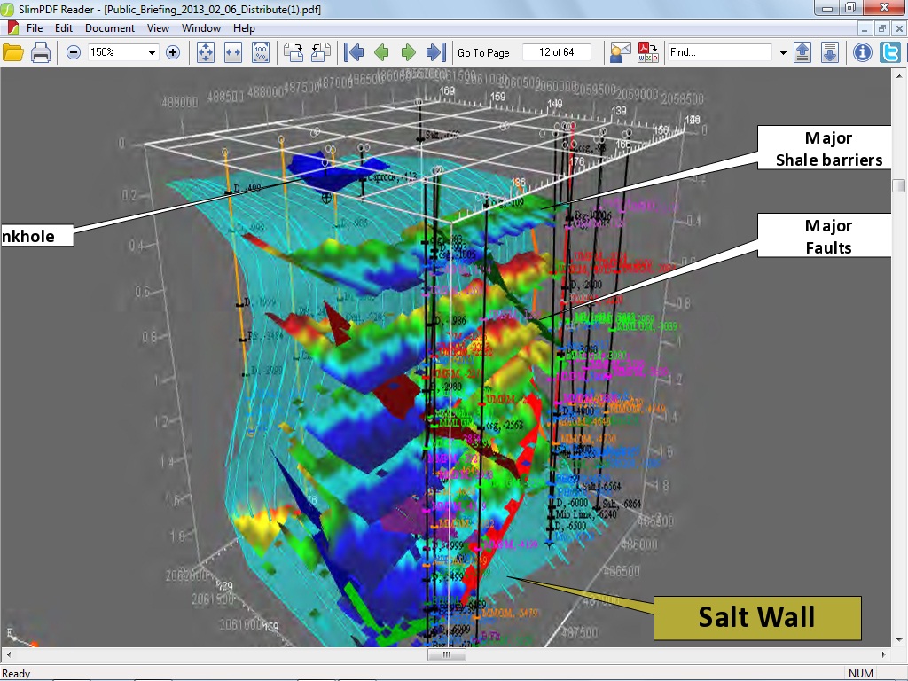
Recall that the Oxy #3 cavern was at a depth of 5,923 ft. deep, and Hooker Oil Well #1 (later changed to SUA 6200), was drilled to 6200 ft. just 980 ft. (surface wellhead) from Oxy #3 (surface wellhead). The top of hydrocarbon sand formation was at a vertical top of approximately 4235 ft., and a bottom depth of approximately 6500 ft. dropping even lower along the gradient of the salt wall, according to the 2007 3D survey, so now it is time to do some quick math.
At surface 980 ft. between wellheads, and taking into account half the volume of the bottom of Oxy 3, which was 300 ft., then we are left with 150 ft (+/- 30 ft.) jutting to the west side from center of bore. Then taking into account an ‘M’ sands formation of approximately 900-1000 ft. (squared) pay extrapolated from nearly 20 years of production before considered depleted, due to the drive force reaching static pressure, (usually a water drive, but sometimes other drives exist, likely methane gas, and does not mean empty, just no longer able to recover hydrocarbons), with an offset casing of 338 ft. towards the Shale Sheath, leaving 750 ft. (horizontal) pressuring the shale sheath eastward with the formation top at 4235 ft. and a sloping bottom formation depth of 6500 ft. (vertical) leaves us with only 50-80 ft. (again +/- 30 ft.) of Shale Sheath seperating the Oxy #3 cavern and the bottom 1016 ft. (vertical) of said Cavern 3 being pressured by the oil formation against the Shale Sheath, as shown by the straight line deformation of the SONAR survey of Oxy #3, with pressures slowly falling over the years of the oilwell’s useful lifespan, while at the same time Texas Brine is mining salt from inside the Salt Dome’s edge, therefore exposing more of Cavern 3 to the shale sheath over it’s useful lifetime.

(Click all highlighted text and all images to enlarge and open)
Now if that doesn’t clarify things for you, then it sure should have left the reader completely baffled. Essentially, a very thin shale sheath was separating the bottom 1000 ft. of the Cavern from the pressuring oil formation abutting against the sheath. This pressuring could have been a good thing until the pressures decreased and not exerting the same amount of force as it previously did before being produced. Any Geologist worth his salt, (pun intended), could see the straight line deformation of the Sonar scans of Occidental Geismar Brine Well #3, and realize it was pressing against a solid surface and not an elastic one such as salt rock which is never in a straight line.
ERRORS PLUS A GAMBLE: (Part II)
The Mill Out:
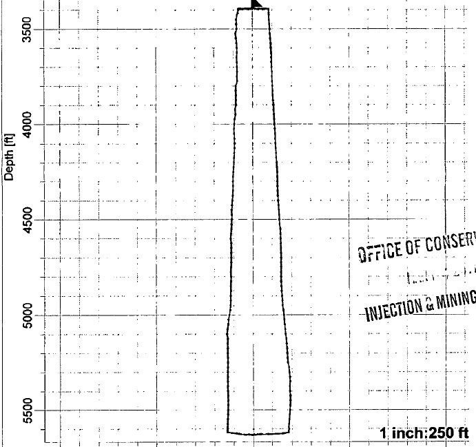
It seems ever more self-evident that Texas Brine knew what was happening with Cavern 3, and made plans in 2010 to abandon Cavern # 3 in favor of milling out an upper cavern starting at 2380 ft. Remember the top of Cavern 3 was at 3400 ft. so this left Texas Brine with nearly 900 ft. of salt above Cavern 3, (once they cemented the top of this cavern), and 1400 ft. above to stay safely below the caprock, then, dear reader, please realize how much salt could have been mined from such a space for years to come, and a source of income for Texas Brine and the Owner, Occidental Chemical Corp. if they had pulled this gamble off.
Unfortunately, at best, only 300 ft. of salt existed at 2380-2480 ft.from the outside of the dome, and at worst only 100 ft. of salt separated the dome from the outside shale, and a normal mill out pressure is initially approximately 1500 psi at depth or 0.8 psi per foot of depth, (per Regulations) which would create a cavity of approximately 100-200 ft of open space (horizontally, and at least 100 feet in vertical height) around the wellbore casing using freshwater. It is my contention, and the opinions of others far more experienced than I am, that the salt was breached into shale and the overburden of the salt overhang slammed down and thereby set off a nearby fault line in the shale, which was truly the beginning of this entire disaster. The shale sheath protecting Cavern 3 fractured as a result of this Mill Out, and cavern pressures were immediately noted to be dropping.
Suspecting this was the case, and thinking they had miscalculated, then Texas Brine commissioned Baker-Hughes to come in and run a Vertical Seismic Profile, (VSP), on September 25, 2010, and permitted by LDNR and Conservation, to map the edge of salt after the fact, instead of doing so before the fatal Mill Out of 2010.
An engineering blunder that is costing them unto this day, yet Occidental is still the Owner of the Cavern and of the land and mineral rights, and suffers none of the liabilty publicly. One wonders what the agreement is between the two companies that allows this situation to occur?
As a reminder, here are the results of that VSP.


It has been postulated by Mr. Gary Hecox, and Mr. Will Pettitt, that eight oil and gas bearing formations are pinched up against the edge of the dome and supplying all of the methane gas, oil, and produced waters via the ‘Disturbed Rock Zone’.
It is a flimsy premise at first glance considering the eighth producing formation sand level is over 14,000 ft. deep, and surely natural formation waters alone would not provide a strong enough ‘drive’ to provide the ‘push’ that the heavy hydrocarbons would need to force their way to the surface if not fractured or drilled. Upon further investigation though, maybe they know something we do not. Possibly a very BIG something.
Such as the fact that there are no obstructions between the sand formations at depth, and the E&P Injection Wells within close proximity to the edge of the Napoleonville salt dome. E&P, stands for Exploration and Production Wastes, such as drill cuttings, brine wastes, benzene, toulene, etc. and such, within production water wastes from oilfields. For more information on E&P Wastes, please consult: http://www.epa.gov/osw/nonhaz/industrial/special/oil/oil-gas.pdf
The closest is the old Hallar Enterprises Inc. Disposal Site on Hwy. 70, Pierre Part, La., which is less than a mile away as the crow flies and formerly injected wastes to a sand formation at just over 12,000 ft, deep into a depleted oil well, and fractured shale, where oil sands may easily carry injected produced waters in a south easterly direction. This well has been P&A’d, (Plugged and Abandoned), and the building torn down recently, yet the wastes still remain somewhere, complete with a Flare that waxes and wanes with the Seismic Activity, as does the the ‘Sugar Shack’ Flare off Hwy. 69, very near the 2010 Mantle Oil & Gas ‘Kick’, in which the Halliburton Blowout Preventer malfunctioned, just as it did in the GOM at Macondo/BP….
Next are two wells owned by FAS Environmental Services LLC in Pierre Part, 1081 Hwy 70, Well Serial Numbers 156044, and 973168. One such Injection well Serial # 973168 injected 1,156,970 Barrels in 2011 alone, download the report below:
and
That is 48,592,740 (million) gallons in just 2011 alone injected at a depth of 3700 – 3965 ft. bearing sands. It makes one wonder just what kind of oversight is in place around these Salt Domes to allow such polluted wastes to be slurried into sand streams, and what by-products are generated at depths that could easily be the ‘push waters’, (produced waters), that are possibly the actual drives behind the waters that are forcing hydrocarbons into the Mississippi River Alluvial Aquifer, (MRAA) at the sinkhole in Bayou Corne, as well as forcing the methane gas deposits into the MRAA aquifer as well.
There is nothing we can find to stop the fractured ‘Depleted Oil Formation Wells’ from supplying the surrounding Formation Sands from migrating eastwards, and supply the ‘Push Waters’, (which are Oil Drilling Waste Waters injected into the earth), forcing the oil, and gas into the ‘Great Louisiana Sinkhole’.
As an Aside; I have still not received any answers from Texas Brine, LLC, as to the disposition of their NORM/TENORM deposits, and LDNR refuses my calls. FOIA anyone?
Where are the regulations, statutes, codes, and laws to guard against such irresponsibility? Not only in regards to Deep E&P Waste Water Injection Wells, but to protect the public health and welfare from insane business practices that do not consider the lives, health, or environment in their business models?
THEY EXIST, but are NOT ENFORCED! That is, in regards to injection wells, yet none exist that protects natural Salt Domes, that Geologists have known for a hundred years to be a trap for oil, gas, and waters bourne by the sands around them.
This is a wide spread concern and not just in Louisiana, but this State’s Department of Conservation is a Joke! It’s Department of Environmental Quality has completely DEPARTED, and the Department of Natural Resources seems to be onboard with the Louisiana Oil and Gas Association!
Just as Scott Angelle, the former head of LDNR jumped ship within days of the Sinkhole Disaster, and moved away from the area, to pursue his own interests in the (LOL) “Public Service Commission”, to side-step and avoid the crimes he was responsible for; so too it seems that James Welsh, the ‘Maestro’ behind all of this absolutely horrific breakdown of regulations and rules regarding all forms of Injection Wastes since 1978, and responsible for even more lax over-sight of any Salt Dome Caverns, and Deep Well EP Wastewater Injection Wells that dot most of the State… just skates on away, while the collateral damage of wasted lives, cancer-ridden victims, taxpayers, and tourists, suffer for these ‘Officials’ greed and personal aggrandizement, as well as their hubris…that, in and of itself, to me…. is the most reprehensible of crimes. To drive this point home, please visit the EPA’s Current Conditions for Louisiana: Water Quality, as well as EPA Injection Wells in Louisiana and Violations (2007-2010).
Hopefully, I have expressed the professional opinions of the people that proffer their technical expertise to me free of charge, as well as their personal opinions and professional acumen appropriately, and apologize to these good people for my emotional statements towards the end of this article, yet I cannot regret my words.
It is time for a change. This time for the better. It is OUR WORLD, not the politician’s, lobbyist’s, special interests, nor the playground of big corporations. It is all of ours, and it’s time we take back what is ours.
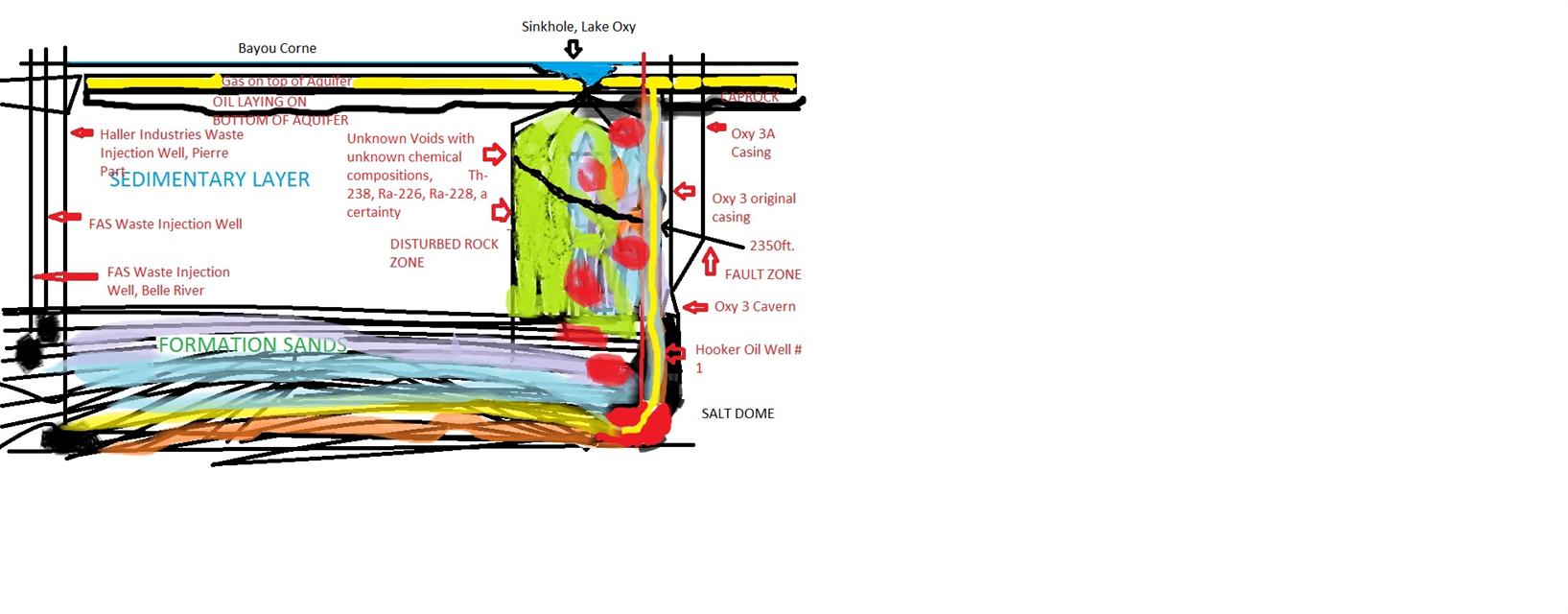
As a parting shot, please take a look at my very horrible graphic, (gimme a break, I did it in Paint), to give a hint as to what we suspect is truly happening beneath the earth on the Western face of the Salt Dome. After intensive study, none of us could find a fault block area that would prevent this scenario from actually taking place, but since none of us can actually stick our heads down 12,000 ft., then of course it is all subjective. (Again forgive the childish quality of the hand painted graphic as it is only for visualization purposes of a probable scenario)
LEGEND:
Red=Oil Formations and flows
Purple=Produced Waters
Green= Chemical mixes
Yellow=Methane gas
Light blue=natural water drives
Orange=Oil Sands carrying lower formation waters, and gases
Blue=Surface Water
Black Spots= fractured sedimentary materials
(Click to enlarge)

Reblogged this on The Louisiana Sinkhole Bugle and commented:
maybe pushing the limits too far this time out of TOTAL GREED … and trying to cover it up!
Agreed, as to the greed, FcF.
Pingback: Reader: An Idea About What is Going On Down Below | The Louisiana Sinkhole Bugle
These companies do not know how to fix this problem , exxon pipeline burst yesterday in arkansa . Oklahoma ‘s largest earthquake caused by oil companies . Tennessee. God help .
It does seem to be spiraling out of control, and has been for a while, especially since the EPA exempted all oifield drilling wastes from HazMat regulations in 1988.
here is EPA Freedom of Info request page –
http://www.epa.gov/foia/make_a_request.html
They long ago stopped replying to my requests. If anyone can get a response please post it here.
well, save that tid-bit for the lawyers!
I was looking around at governmentattic.org … but I got lost 🙂
LOL. Nowadays, you have to be an organization which has the money to sue to get a FOIA on most subjects. The exact opposite of what the law was put in place for. It was supposed to be for Freedom of Information for everyone.
Thank you so much for explaining this. It’s so sad that these greedy people have been allowed to do this to the land and the people. The fact that they have not had to pay any price for their greed and damage to people and the environment is not acceptable. They all need to be prosecuted. It may need to start in the court of public opinion but it really does need to happen. And all these people need to be compensated. These companies must learn that their is a high cost to their pollution. I wonder if we will ever see justice served.
I would have to think so QE, otherwise what would be the point of writing myself to death? 🙂 I will accept the Court of Public Opinion anyday, over ‘Officials’ being lobbyied, whined, and dined by industry on a daily basis.
Thank you.
This makes more sense to me than anything being reported by the industry or the governing bodies which should be regulating them.
There has got to be a way to put an end to this dangerous greed & corruption!
Thank you for reading GZ. Of course with only the limited release of information, even our panel is having a hard time piece-mealing it all together. So much for Mr. Marlin and others being able to get a 3D out to the Public within days, as promised at the Town Hall Meeting.
One of the mornings when I opened so many links I’m not sure which source they came from. I’ve been trying to back track by searching the hyper link, but haven’t got there yet.
The maps (ArcGIS JavaScript ArcGIS.com Map Google Earth ArcMap ArcGIS Explorer ) gave me great insight/understanding> http://mimir.lsu.edu/maps/rest/services/Projects/Sinkhole_2012/MapServer
There’s lot’s of data available there, I just don’t understand it, therefore I’m passing it to you folk’s who can make use of it if you aren’t already.
Great research Freedomrox & other scientists. The Carnival Barker and Hypnotist thought everyone could be fooled.
Thanks Keith and they actually read what I publish, so I am sure they appreciate it. As for fooling everyone, Texas Brine has to take first place in that one. How anyone can say, “I did not write what I wrote.”, and do so with a straight face surely takes First Place as judged by the Blue Ribbon Commission…:P
Thanks Rox. Good work and good info. It just keeps getting worse.
Yes, and many more disasters await us on the horizon. LDNR is allowing the same type of situation to develop at Jefferson Island with AGL. An issue I find I must embrace as well… (sigh).
Great research!!! Thank you! Am very appreciative for people like yourself who show us where and how to access these records…how to work toward changing industry practice in our state. If more of us took the time to truly study the technology being used around us and investigate the activities of these industries, it would be much more difficult for them to get away with side-stepping regulations, bribing our public officials, polluting our environment and poisoning our families. Our citizens must change their behavior before the corruption will come to an end. ALL OF US must rally and work together to protect each other. We are all capable. Your group has been an example that I pray will be repeated throughout our state! I encourage everyone within earshot to call/write the Attorney General requesting a legitimate investigation into the activities of the LDNR, the DEQ and all of those conducting business near the Napoleonville Salt Dome! Send others here and repost to other blogs. Let’s let the politicians, regulatory agencies and industry moguls KNOW that we have changed…and we will be expecting them all to change as well!!
Reblogged this on MisBehaved Woman.
Reblogged this on Family Survival Protocol.
Pingback: LOUISIANA SINKHOLE: COMEDY OF ERRORS OR INTENTIONAL GAMBLE? | Family Survival Protocol
They must be desperate to take info from you to make their phoney report!
It also shows great lack of imagination.
I think some low-budget PR firm must have dreamed this (3-D report Tex Brine just issued) up.
Don’t they know putting out a document with this many false claims will give ammo to litigants? Oh, well, as long as they are digging their own grave let’s lend a hand!
Pingback: Louisiana Sinkhole: Jindal’s Folly | freedomrox
Pingback: Reprise – LOUISIANA SINKHOLE: COMEDY OF ERRORS OR INTENTIONAL GAMBLE? | The Louisiana Sinkhole Bugle
Greetings! Very helpful advice within this post!
It is the little changes that produce the biggest changes.
Thanks a lot for sharing!
Pingback: Louisiana Sinkhole: Dramatic Footage of Collapsing Sinkhole | freedomrox
Hmm is anyone else experiencing problems with the images on this blo loading?
I’m trying to figure out if its a problem on my end or if it’s the
blog. Any suggestions would be greatly appreciated.
Pingback: Really wanting to copy this info, it needs to be seen and not covered up. | My Blog
Everything here is for public consumption. Feel free to copy and post anywhere as long as a link back to the original is provided. Thanks.