

(Photo courtesy of LDNR)
A meeting was held on February 6, 2013 and was pre-empted by an impromptu disruption by one Cathy Simoneaux. I have no opinon of her allegations.
http://theadvocate.com/news/ascension/5120124-123/meeting-gets-contentious
Unfortuately, this sensationalised story took the center stage and prevented a much greater understanding of the actual issues at hand. Many speakers gave presentations, and for once the residents of Bayou Corne got far more answers than they were prepared to handle.
Residents were literally diluged with information that took most off-guard, and having to view the videos to get even half the information that was imparted to them. This is truly understandable, considering the months of stone-walling, and jibber-jabber with no real answers. This is not the case now.
Finally an understanding of the Bayou Corne ‘Sinkhole’ may be at hand. Instead of boring you with a run down of each and every presentation right off the bat, let’s just introduce the Presenters, or their affiliations, and their results in a quick nutshell.
First, we had Shaw and the Louisiana Office of Conservation that hired petroleum geophysicist Don Marlin to interpret three-dimensional seismic data that Texas Brine Co. LLC is planning to collect around the sinkhole.
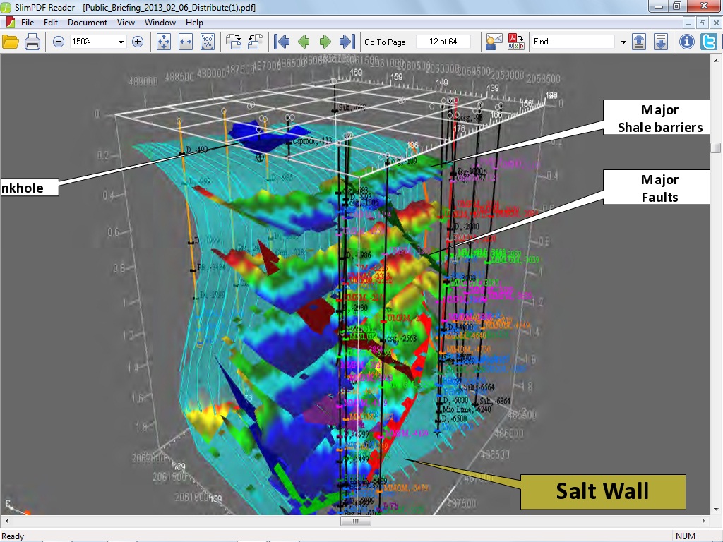
According to the 2007 ‘proprietary 3-D survey’ obtained from Golden Gate Petroleum, the small .3 mile survey was presented as thus:
Source: http://tinyurl.com/aurdts2 (Pages 12 and 13)

According to Mr. Marlin, blah, blah, blah. (I can do this, no one can fire me from my own blog) <This view is from the West, as if you were looking at it from Bayou Corne>
(Warning! Author’s informed interpretation and rant follows)
Truth is, this 3-D Survey reveals some very telling details. Although not definitive, it seems the working theory is this: Texas Brine milled out a section around 2350 ft. right on a major fault section closest to the casing, not considering they had very little salt to work with there. The salt is either washed away and damaging the shale formations close to the fault line, or overpumped freshwater in the millout to have accomplished the same thing.
(Start at the 5 Min. mark if it does not go there)
Here, Mr. Gary Hecox admits the geologists of the time thought the salt extended out another 1,000 ft. in 1982, yet fails to mention the voluminous records of SONAR surveys, (latest was 1997), or the Vertical Seismic Profile in 2010, which definitvely showed the cavern laying upon the shale sheath.
(Additionally a lower, lesser fault line is shown and not identified as such further north and under the sinkhole, running along the blade of the knife-looking structure in the graphic.)
This gave the fault the impetus to become active, (meaning fracturing the fault line rock formations), until over a matter of a year and a half; the fault grows bigger as does the mini-quakes, fracturing more rock as it grew, until it essentially shook the shale sheath, (upwards and downwards equally), to pieces and caused the cave in, which in turn took out the remaining shale sheath at depth and cracked the cavern portion that was known to be laying entirely on the shale rock sheath, and this caused the frack out.
This reached to a depth of about 6000 ft. since the overburden pressures caused a momentary pressure of over 7,000 psi. It was a mighty geological explosion, as evidenced by it clearing a path to the surface, and the sinkhole culminating outside the salt dome. Most sinkholes have occured over the top of salt domes, so this is truly a geological first, and at the same level of the oil, gas, and water formations that were pressuring the shale sheath from the west side. A fact known since 2007 by LDNR, Texas Brine, and by the owner of the property, Occidental Chemical Corp.
This information should have been known months ago. The 3 D survey would have shown it just as well then, if not for Golden Gates ‘Proprietary’ legalese. In an emergency situation, nothing should be held up for months over ‘proprietary’ concerns.
Also looking at the depth of the hydrocarbon formations, then there are many culprits at varying depths, but since Oxy 3A is still producing hydrocarbons, then we do know it is at depths greater than 3700 ft. in that area. What is not known is essentially whether the uppermost formation is feeding the sinkhole or not..
(DISCLAIMER: End of Author’s interpretation and rant. This is not to be construed as what Mr. Marlin actually stated, but the inference thereof)
Actually Mr. Marlin was a fount of information, as he informs the audience of the 3-D survey showing a depleted hydrocarbon formation that was drilled into and produced for 15 years, (UPDATE BELOW VIDEO), but the wellbore to this depleted formation is very apparent and clear. Also near the end of his presentation, he is able to describe the salt wall almost to a tee, as it was in 2007. Valuable information indeed. Please watch this short video, as it lends much to the reader’s understanding of the geology of the region.
UPDATE:
Upon further investigation, this tells a very sordid story of Hooker #1 Oil Well. A drama in and of itself.
The well was first drilled and completed in 1986 and was a 6300 ft. borehole down to the depleted formation shown in the 2007 3-D survey.
It changed hands a few times until Energy Self Service Oils, Baton Rouge, La. took it over in 2006, then sometime between then and Feb. 2009, just up and walked off.
Orphaned without a word to anyone. The state had to come in and P&A the well themselves in 5/12/2010. This was an open well, a fire hazard on the surface and right next door to the Oxy #3 cavern and at the same depths, Unreal.
This depletion of this formation right next door to Oxy 3 and the salt dome may have had a role to play in all of this. Just absolutely mind-blowing the level of irresponsibility, and a “I don’t give a damn,” attitude.
(Sources, With Photos:)
and
Location of the well is the same as the leaking water well on this map.
The next Presenter was ITASCA, and Dr. Pettitt, who explains the rock fracture zone that is building up gases until they overwhelm the fractured rock voids and released in the ‘burps’, and then sucks back down water. He cannot actually explain the process, as it is unique in the world of geology. He also admits not knowing the size, nor shape of the ‘disturbed rock zone’ nor what effects it may be having upon the Salt Dome wall.
Although ominous, so far the closest cavern (Oxy #2) is holding it’s integrity, and while the diesel blanket was being replaced to protect the top of the Oxy #2 cavern ceiling on January 19th, no activity was recorded in the cavern during these two seismic events. Although only 370 ft. east, it seems that Oxy #2 showed no signs at all of losing integrity. Good news indeed.
He also explains in detail the seismic readings, which I won’t go into here, but if interested, watch Part 10 at Assumptionla You Tube page:
http://www.youtube.com/user/assumptionla
Next up, was Dr. Gary Hecox, and we have already touched upon what he had to say, but he did give a grim report to the residents regarding gas vent wells in the community. Many of these wells and the intendant piping may well become a permanent fixture, yet he did hold out some hope that the new 3-D seismic survey will identify the formation responsible for the methane gas, and that if so, a well could be drilled to depth and release the pressures long before they reach the aquifer or the resident’s community.
Once again, and pulling no punches, Mr. Hecox stated that all the Bayou Corne homes should be evacuated. The Evacuation Order was appropriate. This should be latched onto by the media and residents, and put forth to Texas Brine and Occidental Chemical Corporation, as well as Louisiana Dept. of Natural Resources to provide the necessary funds to accomplish this objective and buy-outs made available to those that wish to do move on with their lives.
In a very shocking statement, Mr. Hecox admits, they all were in error by trusting the PDK logs to detect gas in the larger water well’s casings and multiple casings, (PDK: An electronic neutron generator in the tool produces pulses of neutrons which spread into the borehole and formation.)
Now, the spread and extent of the methane gas eastwards is in question, and another tool to detect the gas must be found. This is an astounding admission, and Mr. Hecox should be thanked for his honesty and integrity, to be able to admit his own limitations. To address this new issue, a Dr. Charles Faust of Tetra-Tech, is being brought in to develop a better gas mitigation model. This seems apropo in this ‘Faustian environment’.
Also disclosed, and as reported by this blog, two events actually happened on January 19th, 2013. While officials at the time claimed the seismic activity immediately abated after the ten a.m. event that displaced 15,000 cubic feet of water down the sinkhole funnel and into the unknown voids below, but also that there was a second six p.m. event that was much larger and displaced over 40,000 cubic feet of water for a total of 55,000 cubic feet of water that was sucked under the earth as methane gas escaped to the surface, presumably an equal amount, yet that would be inaccurate as it seems the Mississippi River Alluvial Aquifer sands and gravel broke up the gas bubble and diluted it among the aquifer itself, and shunting the most part of the methane under the community and subdivision itself, via the aquifer. How far east is still unanswered.
This is pretty much a run down of the whole meeting, except for resident’s questions, and they are very important questions that I would highly recommend that you watch.
That being said, the residents were very inquisitive about the new gas wells going into the subdivision, and were pretty vocal about it. To the point that Mr. Hecox was struck speechless twice. Several voiced they did not want them in their front or backyards, and if they affected an area 500ft. square, then put them at the land boundries.
Finally one resident, who was very bright, suggested the usage of Four wells out in the swamps and using a steerable bore drill to alleviate the pressures without all the mini wells and piping. It is a non-invasive solution. It is one that Oxy and TB will not want to pay for, but the issue can be forced if no one signs the releases and allows all the tiny wells to go in. However, this will not stop Texas Brine from drilling at all the land boundries, and ignoring the resident’s wishes, while looking and pressuring for that one or two, that will allow vent wells in the middle of the subdivision. That would negate the need for Horizontal Wells, and completely ignore resident’s concerns. As we all know, that seems to be Texas Brine’s style.
Yet, If the Resident’s calmly state their case and even in writing, explaining that the technology Dr. Hecox stated in this video is available and that this non-invasive method is best. Horizontal relief wells are available, but they won’t be, if the residents sign away their rights and Texas Brine, Occidental Chemical Corp. and LDNR’s liability.
There was good news, and bad news, but for the first time, we all have some news.

Reblogged this on The Louisiana Sinkhole Bugle and commented:
lots of info!
Thank you. Can’t wait for the full report! You’re the best site about Oxy Lake 3 by far.
Thank you. Mr. Krug. This was actually a very quick job late at night but I will be working today to make it more professional and to actually impart more of what the ‘experts’ actually said. The above 3-D was wholly my interpretation.
Excellent job!! hard to do! 🙂
Watching all those presentations was like watching the worst submissions to the Cannes Film Festival. Although you want to strangle whoever made it, and get to the point…it is just a film and you have to suffer thru it, no matter what. 🙂
You know how you say Tex Brine is going to take a fall for Occidental? I just thought of Bhopal story. Union Carbide killed all those people in India and to avoid liability they ‘dissolved’ and most of it got turned into a division of Pfizer. I bet that’s the inside plan for this disaster from the business end.
I have thought of that since I saw the ‘Dow’ protest vids. It’s very possible.
Freedomrox, well written and very informative. Packed with information they didn’t want the public to know as evident by their double, technical, beating-around-the-bush speak.
That is the residents biggest gripe. Techno-Babble.. As my Poppa used to say, “If you cannot bedazzle them with brilliance, then baffle them all with bullshit!”
Your thorough research is appreciated. Keeping in mind that I know nothing about sinkholes brine, geology etc, rather I am learning as I go. Please always remember to *speak to people with all levels of knowledge. When you do not assume we know, you invite the opportunity for learning from people who otherwise would stop reading becasue their eyes are crossing. lol. I know that it is hard to balance. Thanks again for working tirelessly on exposing the truth.
I appreciate you and your comments, so please look back in my archives, and it will bring you up to speed, hopefully, so your eyes aren’t crossing by then, 🙂 Again, thanks for being a reader.
I know this is an older article, but it is important to help me get some more background..hoping that you will provided via various sites links to your articles from the *beginning… a package per say. At some point a brief summary of those articles up to today’s date will help in a different way. That would give us, when we do not have time a chance to get most of the story. I apologize if I am asking too much. But I do know, sometimes we do not have time to read a full article, we just need the basic details. At other times we can go back to read the complete article.
I will attempt to do a compilation, but understand please that this has become a very twisted issue, and a political hot potato as well. Most of my articles are not long and can be accessed by hitting the Home/Archives button. I only have written 15 articles here, so take a few days to get familiar with the subject, and if still confused??? Join the club.
Mary Refling here, a New Yorker concerned about plans to turn an abandoned salt mine on the edge of Seneca Lake into a storage hub for natural gas produced by fracking the Marcellus Shale. http://gasfreeseneca.com How much of the Bayou Corne’s bubbling gas is due to ruptures in nearby salt caverns being used for LPG storage? Or have the methane/butane/petroleum bubbles been released via cracks in the shale surrounding naturally occurring petroleum deposits?
I’m so happy that you have provided such extensive details about the mess at the sinkhole. I’m sending links to all on my contact list. More people need to know about this disaster and become involved. Keep up the good works, chere’.