SMRI and Blue Ribbon Commission’s Conflicts of Interest.
by: Freedomrox
As much as the Corporate Program known as “Responsible Care” is plastered on the Water Tower near Bayou Corne, and is a global initiative for every Corporate Member at the Napoleonville Salt Dome, but is not associated with Texas Brine in any way, except for the fact they are members along with every Company that does business on the Dome, yet is often misunderstood as being Texas Brine’s motto. Of course, as we’ve seen responsible care is the last thing to be associated with Texas Brine, LLC.
Yet again, almost every single Company at the Dome is a Member, as is many of the Service Companies, and Support Services are shown to be Members of the Solution Mining Research Institute. It seems to be a prerequisite to doing business there.
What is much more disturbing is the fact that nearly half of the Members of the Governor Bobby Jindal’s appointed Blue Ribbon Commission are also Members of the Solution Mining Research Institute, (SMRI), or closely affiliated. These incestuous relationships call into question the objectivity of such a Commission whose lion’s share of it’s members owe allegiance to a Texas Brine co-founded Solution Mining Research Institute, and yet one that owes no allegiance at all to the people of Grand Bayou/Bayou Corne.
This is shameful and disingenuous at best, but, of course, that is only one man’s opinion.
At the website of the Institute, are some disturbing admissions, such as;
“The Solution Mining Research Institute (SMRI) is interested in the production of salt brine and the utilization of the resulting caverns for the storage of oil, gas, chemicals, compressed air and waste” (sic)
as well as;
“SMRI has the following purposes:
Sponsor and engage in research related to solution mining, cavern storage/utilization, and environmental effects thereof.
Present papers of current interest to the industry relative to solution mining and cavern utilization. For information on presenting papers at or attending our next conference, see ‘CONFERENCES section.
Serve as a technology center and representative for the industry.
Assist in the promulgation of governmental regulations and laws affecting the solution mining industry.”
Number 4 will become very disturbing, very quickly as you shall soon see.
Now, let’s take a look at the Blue Ribbon Commission Members:
Pierre Berest, Ph.D., Research Director at France’s Ecole Polytechnique, member of French Commission for Underground Storage Safety, former president of the Solution Mining Research Institute.
James Linn, Ph.D., Geotechnical consultant, former president of Solution Mining Research Institute, former Underground Storage Technology Manager for Sandia National Laboratories.
John Voigt, Executive Director of Solution Mining Research Institute, President of Voigt Mining and Geotechnical, specializing in salt geology and brine/water inflow evaluation.
Doesn’t look too good so far, does it, but not too damning, until we get to the other members, that is. Please keep this one fact in mind when you see the following names, attached to Sandia National Laboratories, and CB&I, (formerly Shaw Group) for they are members of the Solution Mining Research Institute.
David Borns, Ph.D., Geotechnology and Engineering Program Manager for Sandia National Laboratories, research focused on subsurface monitoring for environmental applications, risk assessments and simulations.
Gary Hecox, Ph.D., Senior Hydrogeologist and GIS Analyst with CB&I, technical lead for CB&I Bayou Corne response team.
Blayne Hartman, Ph.D., Geochemist with Hartman Environmental Geoscience, contributor to regulatory guidance documents on vapor intrusion for EPA and several state agencies.
As for the rest of the Commission, I have no opinion, and not casting aspersions upon any of the members of the Blue Ribbon Commission or their character, nor integrity. However it is apparent that conflicts of interests do arise, especially in light of the information as listed above, and becomes highly sensitive where the Blue Ribbon Commission is concerned, since they have been charged with public safety, and is of immediate concern for the residents, as stated in the Blue Ribbon Commission’s Mission Statement;
“To provide benchmarks for the recommendations, the commission will address at least two key factors, including appropriate conditions to determine sustained public safety and the data needed to assess those conditions. The commission will make recommendations on what the safety benchmarks should be and on when they have been sufficiently met.”
Now for information that has absolutely stunned me, and still cannot quite believe, but here it is in black and white and a possible reason why the State seems to be squarely upon the side of industry, especially in light of #3 and #4 of SMRI’s Mission Statement:
“Assist in the promulgation of governmental regulations and laws affecting the solution mining industry.”
An alarming statement considering a member of the Solution Mining Institute is:
I leave it to the People affected by this disaster to make their own minds up as to the information contained above. I am merely the researcher and the messenger.
Personally I have grave reservations over any Texas Brine co-founded Solution Mining Research Institute’s abilities to affect the decisions of the Blue Ribbon Commission as well as Louisiana State Government, when it’s members include the key elements of the State and Federal governments that are charged with regulation and safety of the people of the State of Louisiana and beyond.
Now we can understand why all common sense and restrictive bills upon solution mining fall by the wayside. My heart also goes out to the people of Jefferson Island and Lake Peigneur, for AGL Resources is also a member of this very powerful and politically influential Solution Mining Research Institute.
Today, May 20, 2013, marked a milestone in Louisiana history, whether anyone knows it or not. Governor Bobby Jindal visited the people of Bayou Corne/Grand Bayou and gave the most hypocritical speech that I have heard in a very long time. Of course, in the world of politics, this is seemingly an everyday occurrence, yet this one took the cake, so to speak.
After listening to Jindal, in spite of his political bluster, stood at the podium and admitted that there was nothing they could do about Texas Brine LLC’s failure to live up to it’s promises and deadlines concerning resident buyouts, other than to issue empty threats about permits. If Jindal really was serious, then he would authorize an official investigation into Texas Brine’s business practices and the many laws they have broken throughout the years…and there have been many!
The “Go To Patsy”, that was forced to follow Scott Angelle; Mr. Steven Chustz, has still not provided an answer as to where the location of 50 salt cavern’s worth of ‘radioactive scale’ for the last 50 years has disappeared to, nor it’s disposition. Also, no word has come from the Senate Committee that asked Mr. Chustz to report on the 1991-1994 cavern injections, or upon the Solka Floc slurry system both LDEQ and LDNR illegally signed off onto. The point is not whether radioactive materials were actually injected, or burned, or simply dumped in a landfill, (which would be a separate crime all upon it’s own), but the fact that the laws of the time were broken and between Louisiana Government Agencies, and Private Companies, constituting Conspiracy, ongoing cover ups, and RICO violations.
Remember please the dishonest way that Texas Brine, LLC has acted since this disaster first began, as evidenced by Texas Brine LLC’s claim that earth tremors caused the failure of its salt cavern,
Parish Officials and Stephen Chustz fired back at Texas Brine’s silly statements, amid a slough-in that opened the caved in sinkhole even further. Texas Brine’s response was that the event never took place.
Finally after repeated threats and missing several deadlines, Texas Brine states they will play ball and follow the Directives, and finally sink their first vent well in November, three months after the fact.
Conservation brings in Shaw, (now CB&I), which is a partner of Texas Brine’s in the Texas Brine co-founded ‘Solution Mining Institute’, as is;
Sandia National Laboratories
Class B
Mr. David J. Borns
Dept. 6113 – MS 0706 P.O. Box 5800
Albuquerque, 87185-0706, NM
United States
+1 (505) 844-7333.
Does that ring a bell? Isn’t Mr. Borns on the Blue Ribbon Commission? Isn’t Dr. Gary Hecox of CB&I? As is Pierre Berest, Ph.D, James Linn, Ph.D., Geotechnical consultant, former president of Solution Mining Research Institute, and John Voigt, Executive Director of Solution Mining Research Institute. Seems a conflict of interest here. SOCON, and Baker Hughes are all members as well. Dow is a member as well as Sabine Storage & Operations, Inc. from Houston, TX. This will be important in a moment.
The point of this article is not just about the incestuous relationships between all operators on the Dome, or the companies that service them, although it is one helluva point all on its own, nor is the point that the LDNR, Conservation, and LDEQ, that permitted, encouraged, and helped cover up the problems Texas Brine knew it had already caused, and all involved covered that fact up; are now working in tandem to fix the cover-up. No, my point has nothing to do with the ‘Foxes guarding the Henhouse’, but maybe it should be.
The real point is that despite Governor Bobby Jindal’s threats and blustering, will not mean a whit in the policy making processes of the Insurance Companies resistance to a precedent-setting and historical decision. What decision, you may ask? The one of paying off the victims of a disaster to the tune of possibly half a billion dollars, before liability has been set forth by a court of competent jurisdiction. That is the one point that cannot be ignored, and I have noticed it being the center of a buzz, and is constantly bandied about on nearly every Insurance blog on the net in the last year.
Think about it; just how much of your daily life is controlled by Insurance Companies? Which industry successfully lobbied for every single person to be forced to carry Auto Insurance, or be fined? Which industry will not even allow a bank loan to issue for your own home, unless you carry homeowner’s insurance? Cargo Insurance, etc, etc., ad nauseam?
If Governor Bobby Jindal was truly serious about helping the people of Grand Bayou/Bayou Corne, then I find myself reluctantly agreeing with Mr. John Achee Jr.’s stance of the Governor pleading for federal assistance to come in and take over this truly un-natural disaster. I know this is not popular with the whole community, and a healthy distrust of the Federal Government, (especially in light of the recent tyrannical scandals of late), is entirely understandable, but please allow me to explain.
With Federal Assistance, the Army Corps of Engineers and their unlimited resources would come into play, as well as the National Disaster Relief Fund, which would place the full resources of the federal government, and State Agencies to the task of finding a true mitigation of this ongoing, slow-motion disaster. Also, buyouts would be handled with Federal and State funds, and it would then be the responsibility of the Feds and the State to sue Texas Brine and Occidental Chemical for reparations, and the burden not be laid at the feet of the resident’s and unintentional victims to recover in long drawn out court battles that may last 10-15 year; which is where this seems to be heading.
Those not wanting to leave should stay in the Mandatory Evacuation Zone and be prepared to suffer any of the consequences of that decision, but those that want to move out of the way of this slow motion train wreck of enormous proportions should be compensated, and allowed to move on with their lives.
I have not even delved into the probable forthcoming victim’s of Pierre Part as the methane has migrated to the western edges of the MRAA aquifer, and damages already being reported in that area. LDNR, LDEQ, and Conservation have completely ignored all complaints and reports, many times with outright lies and obfuscation. This cannot be allowed to go on, and it won’t. More on that in an upcoming article.
I state that if something is not done very soon in respects to the long-suffering victim’s, that a clarion call should be raised that the Governor be impeached, and charges brought against all State Agencies, as well as the Federal Government, for not responding to a National Emergency regarding the Nation’s Energy Supply, and refusing to protect National Security in these regards.
Whether anyone truly grasps the scope and scale of how important this region is to the National Interests and Security is irrelevant, for the State and Federal Government already know and have failed the People of Louisiana, and the People of America, in their lackadaisical response to this highly sensitive area of our energy supplies, as well as ignoring the environmental stability and well-being of a major watershed and wildlife habitat.
The State Agencies involved should be restrained from issuing any further drilling permits, [four (4) in the last ten months for the north, south, and east sides of a water-infiltrated, and fractured Napoleonville Salt Dome], and a permanent moratorium on the design and engineering of any new Solution Mined Caverns anywhere on the Dome should be a part of the Orders and Directives, while allowing the ones already in operation to remain, under close scrutiny. No one is suggesting Corporations should abandon the Dome, (although Gulf South fled it’s Magnolia Facility, and Chevron is in limbo), but until the extent of the damages, and infiltration to the Salt Dome are honestly assessed, then it is not too much to ask that no more caverns should be created until answers are known.
Which brings me to my last point, and one that should outrage each and every one of you, and while still there, should fight with every ounce of energy at your disposal, and that is the recent Public Notice that appeared in the Bayou Journal by Sabine Storage & Operations, Inc. from Houston, TX, and on behalf of Dow Hydrocarbons Resources Inc. All contacts, phone numbers, and mailing addresses are included in this notice, and if you agree, should definitely make your voices heard, and stop this irresponsible and hazardous activity.
Just on the off chance no one actually clicks the link above, then please understand that it contains a Public Notice that Sabine, and Dow intend to solution mine another additional cavern to the South East Side of the Napoleonville Salt Dome nearest Napoleonville, La.
(More may be added to this post as available, and special thanks to the local, who sent me the Bayou Journal notice, and Kenny Simoneaux as well.)
(Special Thanks to On Wings Of Care, and Ms. Bonny, and the Power Hour)
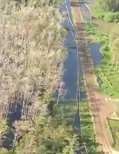
I have avoided for a while giving my opinion and the opinion of many others, the light of day concerning how this geological nightmare in Assumption Parish, Louisiana, also known as the “Great Louisiana Sinkhole”, came into being on August 3, 2012..
I can no longer put this off as so many have sent emails asking for my humble opinion and compilation of the events that led up to the present situation. Please take into account this is not just my opinion alone, and that there is a reputable geologist, hydrologist, seismologist, and a salt rock mechanic, (geologist specializing in salt rock formations), that comprise the team that makes this blog possible. All are volunteers, and they are all greatly appreciated. Most are still engaged in their respective fields, and therefore cannot be named at this juncture, for fear of retaliation.
With that firmly stated, and acknowledged, then on with the explanation as we see it.
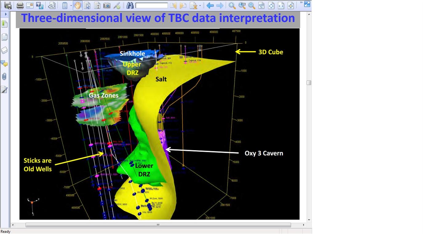
First we have Hooker Oil Well #1 that was drilled to a depth of 6,200 ft., which is why it was later named 6200 RA SUA , (HookerOilWell1 History). The well was first drilled and completed in 1986 down to the depleted formation shown in the 2007 3-D survey. It was drilled 338 ft. directionally in an southeastern direction for a Bottom Hole Location offset..
It changed hands a few times until Energy Self Service Oils, Baton Rouge, La. took it over in 2006 for Natural Gas, then sometime between then and Feb. 2008, (likely earlier, since its shown depleted in 2007 3D survey by Golden Gate), just up and walked off.
Orphaned without a word to anyone. The state had to come in and P&A the well themselves in 5/12/2010. This shows the actual effectiveness of the Dept. of Conservation, as it took them three (3) years, to figure out this well was orphaned and only because deer hunter’s complained about the oil leaking from the wellhead and rusting tanks left behind. This was an open well, and right next door to the Oxy #3 cavern and at the same depths. The depletion of this formation right next door to Oxy 3 and the salt dome may have had a role to play in all of this due to its proximity just underneath the Oxy #3 Cavern, and I intend to prove just how.
ERRORS: (Part I)
OIL WELL VS. SALT CAVERNEQUALS DISTRESSED SHALE SHEATH
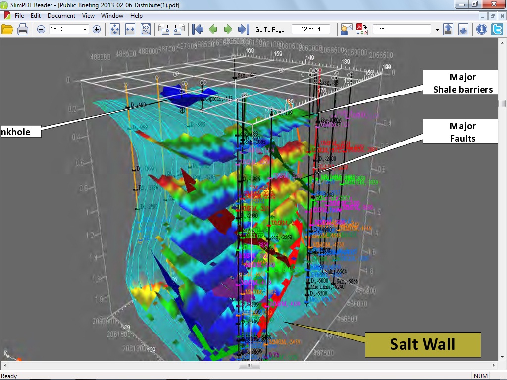
Recall that the Oxy #3 cavern was at a depth of 5,923 ft. deep, and Hooker Oil Well #1 (later changed to SUA 6200), was drilled to 6200 ft. just 980 ft. (surface wellhead) from Oxy #3 (surface wellhead). The top of hydrocarbon sand formation was at a vertical top of approximately 4235 ft., and a bottom depth of approximately 6500 ft. dropping even lower along the gradient of the salt wall, according to the 2007 3D survey, so now it is time to do some quick math.
At surface 980 ft. between wellheads, and taking into account half the volume of the bottom of Oxy 3, which was 300 ft., then we are left with 150 ft (+/- 30 ft.) jutting to the west side from center of bore. Then taking into account an ‘M’ sands formation of approximately 900-1000 ft. (squared) pay extrapolated from nearly 20 years of production before considered depleted, due to the drive force reaching static pressure, (usually a water drive, but sometimes other drives exist, likely methane gas, and does not mean empty, just no longer able to recover hydrocarbons), with an offset casing of 338 ft. towards the Shale Sheath, leaving 750 ft. (horizontal) pressuring the shale sheath eastward with the formation top at 4235 ft. and a sloping bottom formation depth of 6500 ft. (vertical) leaves us with only 50-80 ft. (again +/- 30 ft.) of Shale Sheath seperating the Oxy #3 cavern and the bottom 1016 ft. (vertical) of said Cavern 3 being pressured by the oil formation against the Shale Sheath, as shown by the straight line deformation of the SONAR survey of Oxy #3, with pressures slowly falling over the years of the oilwell’s useful lifespan, while at the same time Texas Brine is mining salt from inside the Salt Dome’s edge, therefore exposing more of Cavern 3 to the shale sheath over it’s useful lifetime.
(Click all highlighted text and all images to enlarge and open)
Now if that doesn’t clarify things for you, then it sure should have left the reader completely baffled. Essentially, a very thin shale sheath was separating the bottom 1000 ft. of the Cavern from the pressuring oil formation abutting against the sheath. This pressuring could have been a good thing until the pressures decreased and not exerting the same amount of force as it previously did before being produced. Any Geologist worth his salt, (pun intended), could see the straight line deformation of the Sonar scans of Occidental Geismar Brine Well #3, and realize it was pressing against a solid surface and not an elastic one such as salt rock which is never in a straight line.
ERRORS PLUS A GAMBLE: (Part II)
The Mill Out:
It seems ever more self-evident that Texas Brine knew what was happening with Cavern 3, and made plans in 2010 to abandon Cavern # 3 in favor of milling out an upper cavern starting at 2380 ft. Remember the top of Cavern 3 was at 3400 ft. so this left Texas Brine with nearly 900 ft. of salt above Cavern 3, (once they cemented the top of this cavern), and 1400 ft. above to stay safely below the caprock, then, dear reader, please realize how much salt could have been mined from such a space for years to come, and a source of income for Texas Brine and the Owner, Occidental Chemical Corp. if they had pulled this gamble off.
Unfortunately, at best, only 300 ft. of salt existed at 2380-2480 ft.from the outside of the dome, and at worst only 100 ft. of salt separated the dome from the outside shale, and a normal mill out pressure is initially approximately 1500 psi at depth or 0.8 psi per foot of depth, (per Regulations) which would create a cavity of approximately 100-200 ft of open space (horizontally, and at least 100 feet in vertical height) around the wellbore casing using freshwater. It is my contention, and the opinions of others far more experienced than I am, that the salt was breached into shale and the overburden of the salt overhang slammed down and thereby set off a nearby fault line in the shale, which was truly the beginning of this entire disaster. The shale sheath protecting Cavern 3 fractured as a result of this Mill Out, and cavern pressures were immediately noted to be dropping.
Suspecting this was the case, and thinking they had miscalculated, then Texas Brine commissioned Baker-Hughes to come in and run a Vertical Seismic Profile, (VSP), on September 25, 2010, and permitted by LDNR and Conservation, to map the edge of salt after the fact, instead of doing so before the fatal Mill Out of 2010.
An engineering blunder that is costing them unto this day, yet Occidental is still the Owner of the Cavern and of the land and mineral rights, and suffers none of the liabilty publicly. One wonders what the agreement is between the two companies that allows this situation to occur?
As a reminder, here are the results of that VSP.
It has been postulated by Mr. Gary Hecox, and Mr. Will Pettitt, that eight oil and gas bearing formations are pinched up against the edge of the dome and supplying all of the methane gas, oil, and produced waters via the ‘Disturbed Rock Zone’.
It is a flimsy premise at first glance considering the eighth producing formation sand level is over 14,000 ft. deep, and surely natural formation waters alone would not provide a strong enough ‘drive’ to provide the ‘push’ that the heavy hydrocarbons would need to force their way to the surface if not fractured or drilled. Upon further investigation though, maybe they know something we do not. Possibly a very BIG something.
Such as the fact that there are no obstructions between the sand formations at depth, and the E&P Injection Wells within close proximity to the edge of the Napoleonville salt dome. E&P, stands for Exploration and Production Wastes, such as drill cuttings, brine wastes, benzene, toulene, etc. and such, within production water wastes from oilfields. For more information on E&P Wastes, please consult: http://www.epa.gov/osw/nonhaz/industrial/special/oil/oil-gas.pdf
The closest is the old Hallar Enterprises Inc. Disposal Site on Hwy. 70, Pierre Part, La., which is less than a mile away as the crow flies and formerly injected wastes to a sand formation at just over 12,000 ft, deep into a depleted oil well, and fractured shale, where oil sands may easily carry injected produced waters in a south easterly direction. This well has been P&A’d, (Plugged and Abandoned), and the building torn down recently, yet the wastes still remain somewhere, complete with a Flare that waxes and wanes with the Seismic Activity, as does the the ‘Sugar Shack’ Flare off Hwy. 69, very near the 2010 Mantle Oil & Gas ‘Kick’, in which the Halliburton Blowout Preventer malfunctioned, just as it did in the GOM at Macondo/BP….
Next are two wells owned by FAS Environmental Services LLC in Pierre Part, 1081 Hwy 70, Well Serial Numbers 156044, and 973168. One such Injection well Serial # 973168 injected 1,156,970 Barrels in 2011 alone, download the report below:
That is 48,592,740 (million) gallons in just 2011 alone injected at a depth of 3700 – 3965 ft. bearing sands. It makes one wonder just what kind of oversight is in place around these Salt Domes to allow such polluted wastes to be slurried into sand streams, and what by-products are generated at depths that could easily be the ‘push waters’, (produced waters), that are possibly the actual drives behind the waters that are forcing hydrocarbons into the Mississippi River Alluvial Aquifer, (MRAA) at the sinkhole in Bayou Corne, as well as forcing the methane gas deposits into the MRAA aquifer as well.
There is nothing we can find to stop the fractured ‘Depleted Oil Formation Wells’ from supplying the surrounding Formation Sands from migrating eastwards, and supply the ‘Push Waters’, (which are Oil Drilling Waste Waters injected into the earth), forcing the oil, and gas into the ‘Great Louisiana Sinkhole’.
As an Aside; I have still not received any answers from Texas Brine, LLC, as to the disposition of their NORM/TENORM deposits, and LDNR refuses my calls. FOIA anyone?
Where are the regulations, statutes, codes, and laws to guard against such irresponsibility? Not only in regards to Deep E&P Waste Water Injection Wells, but to protect the public health and welfare from insane business practices that do not consider the lives, health, or environment in their business models?
THEY EXIST, but are NOT ENFORCED! That is, in regards to injection wells, yet none exist that protects natural Salt Domes, that Geologists have known for a hundred years to be a trap for oil, gas, and waters bourne by the sands around them.
This is a wide spread concern and not just in Louisiana, but this State’s Department of Conservation is a Joke! It’s Department of Environmental Quality has completely DEPARTED, and the Department of Natural Resources seems to be onboard with the Louisiana Oil and Gas Association!
Just as Scott Angelle, the former head of LDNR jumped ship within days of the Sinkhole Disaster, and moved away from the area, to pursue his own interests in the (LOL) “Public Service Commission”, to side-step and avoid the crimes he was responsible for; so too it seems that James Welsh, the ‘Maestro’ behind all of this absolutely horrific breakdown of regulations and rules regarding all forms of Injection Wastes since 1978, and responsible for even more lax over-sight of any Salt Dome Caverns, and Deep Well EP Wastewater Injection Wells that dot most of the State… just skates on away, while the collateral damage of wasted lives, cancer-ridden victims, taxpayers, and tourists, suffer for these ‘Officials’ greed and personal aggrandizement, as well as their hubris…that, in and of itself, to me…. is the most reprehensible of crimes. To drive this point home, please visit the EPA’s Current Conditions for Louisiana: Water Quality, as well as EPA Injection Wells in Louisiana and Violations (2007-2010).
Hopefully, I have expressed the professional opinions of the people that proffer their technical expertise to me free of charge, as well as their personal opinions and professional acumen appropriately, and apologize to these good people for my emotional statements towards the end of this article, yet I cannot regret my words.
It is time for a change. This time for the better. It is OUR WORLD, not the politician’s, lobbyist’s, special interests, nor the playground of big corporations. It is all of ours, and it’s time we take back what is ours.
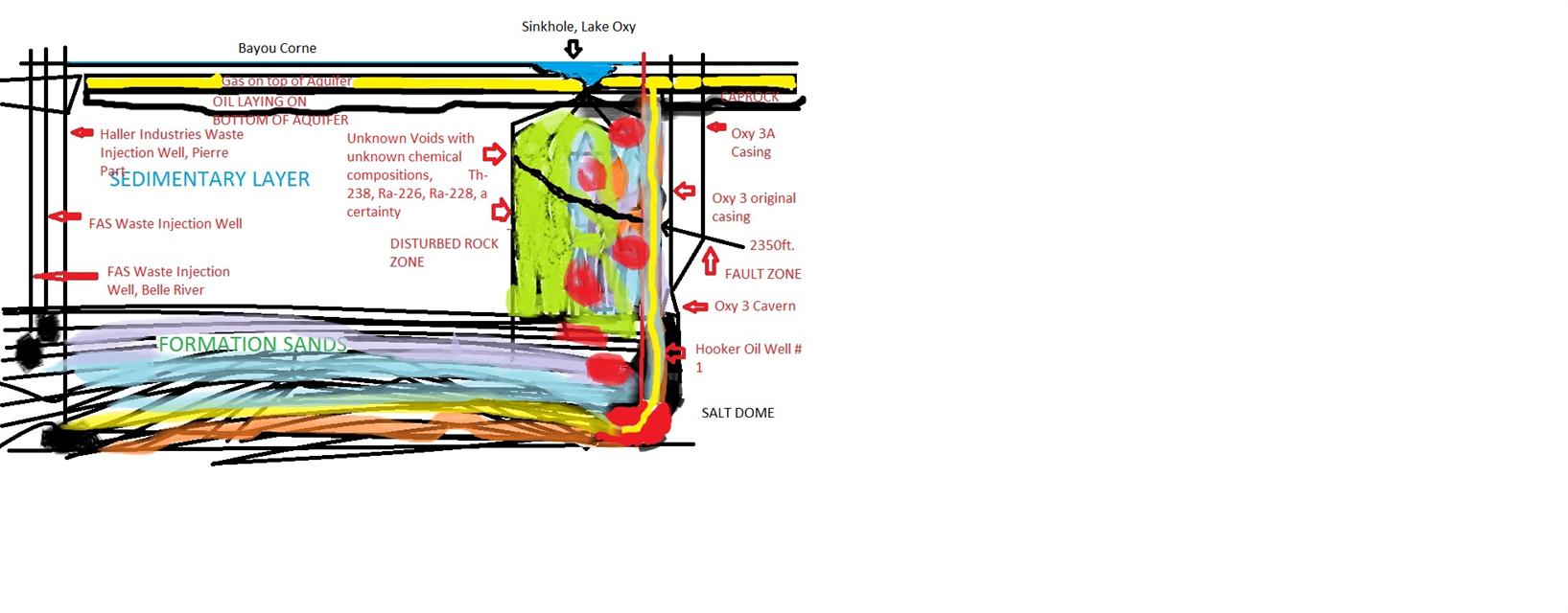
As a parting shot, please take a look at my very horrible graphic, (gimme a break, I did it in Paint), to give a hint as to what we suspect is truly happening beneath the earth on the Western face of the Salt Dome. After intensive study, none of us could find a fault block area that would prevent this scenario from actually taking place, but since none of us can actually stick our heads down 12,000 ft., then of course it is all subjective. (Again forgive the childish quality of the hand painted graphic as it is only for visualization purposes of a probable scenario)
LEGEND:
Red=Oil Formations and flows
Purple=Produced Waters
Green= Chemical mixes
Yellow=Methane gas
Light blue=natural water drives
Orange=Oil Sands carrying lower formation waters, and gases
(NOTE TO RETURNING READERS, THE UPDATE REBUTTAL IS HIGHLIGHTED IN BOLD LETTERS BELOW)
A truly shocking revelation has been uncovered in SONRIS files concerning the fragile and ‘too close to salt edge’, Occidental Geismar #1, as well as four other caverns on the east side of Grand Bayou.
Last week, it was revealed that Oxy #1 was found to be in potential jeopardy and possible collapse since it lies within 1-200 ft. from the Salt Dome’s edge.
Although no real shock to those in the know, what else was found regarding Occidental-Geismar #1 Cavern, turned out to be a real electrifying revelation.
Many community meetings have been held in Assumption Parish with the residents affected by the ‘Great Louisiana Sinkhole’ formed by the failure of Oxy-Geismar #3 salt cavern known to be on the edge of the Napoleonville Salt Dome, by Texas Brine and the Owner of the actual cavern itself, Occidental Chemical Corporation. Although asked about the possible NORM contained by other caverns, no real answers were forthcoming. Now we understand why this was never answered.
Buried deep within the bowels of SONRIS at LDNR and in a well file relating to Gulf South #1 failed cavern that terrorized the community of Grand Bayou in 2003, were documents relating to Texas Brine and Occidental’s dealings with James Welsh concerning the disposal of ‘calcium and magnesium brine precipitates’, later changed to ‘brine sludge’, and both terms meaning Naturally Occurring Radioactive Materials, (NORM), and the injection of these materials back into the caverns in which they were produced.
In a letter dated July 8, 1991, James Welsh in responding to a May 1, and May 29 requests for NORM to be put back into the following Well(s), Serial #’s 142315, 109979, 110339, 151645, and were not only given permission by then Mining Director Welsh to inject, but additionally informed they would have no problems with continuing Class III brine mining from these same caverns but would also have no problem being permitted for Class II Storage Wells if asked for in the future.
Then in 1994, another set of letters concerning NORM passed between Bill Walters at LDNR and Jim McCartney of Texas Brine requesting Well(s) Serial #’s, 109979 again, 151645 again, and 142316, be injected once more, and was again answered by Mr. Welsh on August 23, 1994, and informed that
Even more disturbing is that this time Texas Brine proposed a Solka Floc system that would prepare the NORM to be re-injected into the above documented caverns, thereby transforming the NORM into Technologically Enhanced Naturally Occurring Radioactive Materials, (TENORM), and the Department of Environmental Quality passed it without question, and with only a sketch to go by; with no plans to follow up after construction, before introducing said materials into the caverns, and all unconcerned that these Wells remained Class III brine mining wells, while at the same time, being used for radioactive sludge waste injection caverns.
Before I go further, I feel it is incumbent upon me to inform you, the reader, that not once, but twice OXY GEISMAR #1 is proposed for these TENORM injections, as evidenced by Serial Number 151645, which turns out to be the very cavern that is now suspected of being mined too close to the edge of the Salt Dome, and could potentially fail. I would also like to point out this was done at a time when it was illegal under any circumstances to place any radioactive materials into salt caverns of any kind.
I submit this fact was known far ahead of time as submitted in earlier articles, but further evidence has come to light supporting such a supposition.
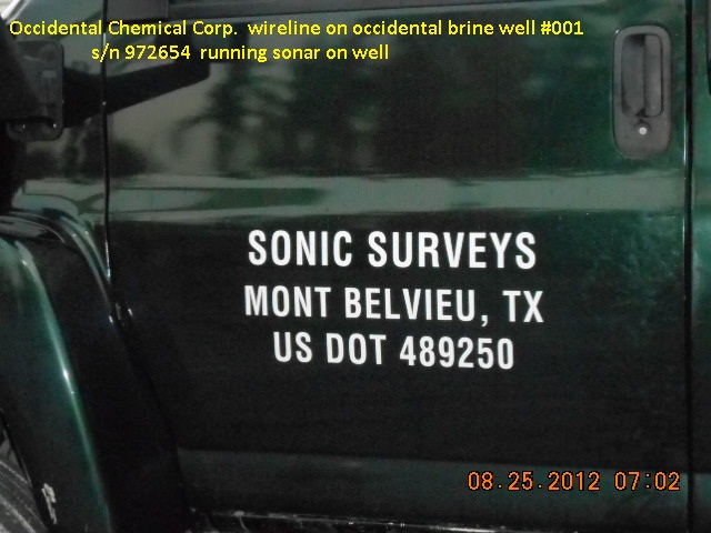
On August 25, 2012 and only three weeks after the OXY GEISMAR #3 cavern had collapsed, Occidental and Texas Brine sent in a team to immediately perform a SONAR scan of Oxy Geismar #1 and of no other caverns as shown in these pictures provided by LDNR.
These pictures and the SONAR of Oxy Geismar #1 screams that Occidental and Texas Brine had reason to be alarmed that this particular cavern might breach out, as opposed to say, Oxy Geismar #2, located directly behind the failed Cavern 3.
This is very disturbing news indeed. Although not a conspiracy minded person…I must admit this smacks of conspiracy and of an on-going coverup.
I do not state this lightly, as Occidental and Texas Brine side-stepped these issues before when questions arose concerning the presence of NORM in Oxy-Geismar #3 by stating that in 1995 they received permission from LDNR, but not from LDEQ. That really seems disingenious in the extreme, considering the Louisiana Dept. of Environmental Quality, Linda Levy, gave full permission in 1994, as did James Welsh, of LDNR Director of Injection and Mining Division, for the TENORM injection of waste materials into 5 other caverns.
If there is even a way for these obviously corrupt corporations and the State Agencies charged with the Safety of the Public Health and Welfare of the People of Louisiana, to weasel their way from under these allegations, then these questions still remain…. If in 1991 there was enough NORM for four wells, and in 1994, enough existed for three more wells, and then with just an average of 20 cu. ft. of NORM that was to be placed in Oxy #3, then we have 160 cu. ft.of radioactive materials floating around in limbo whether just underground in the Solka Floc system and a ‘Tank’, or laying in piles all over the dome, with the many other wells on the Dome, is also the potential for 1000’s of Feet of Radioactive Materials in unknown locations exposed to the elements, or as stated in the above letters; re-injected into caverns, where they could be pumped out to an end producer for potcarb including nutrition supplements for dairy cattle, video glass for television and computer monitors, other specialty glass, potassium silicates, fertilizers, gas processing, industrial intermediaries, photographic development processes, detergents, and food products, such as the Occidental-Geismar Chemical Plant in Geismar. Louisiana, or to Dow, which uses the chlorides for many end user products, such as plastics, and a host of other end user products that could be on a Store Shelf near you.
None of us ever to expected our Bagged Fertilizers, nor our Chlorox type cleaners, to actually glow in the dark. Not stating they are, but it is a valid question.
If this does not spark an investigation by the Federal Government, then what on earth ever will? Raw Milk?
REBUTTAL TO MR. BRUCE MARTIN OF TEXAS BRINE
Apparently the very next day after this article was released Texas Brine, LLC Spokesman, Bruce Martin made a Public Statement concerning NORM injections into Oxy Geismar 1 and 3. Mr. Martin claims no injections ever took place.
(Please go to 4 mins, and 30 seconds of this video to listen to Mr. Martin’s reply.)
According to Mr. Martin, ‘Brine Precipitates’ fell out of the wellheads of Oxy 3 and another at Chacahoula. Just fell out. Huh?
He explains they were so out of touch, they hadn’t a clue what they were looking at… Is that credible? More importantly, is that “Responsible Care”?
He then goes on to explain that you should take his word that over a five year period, 1990, 1991, 1994, and 1995, each citing different Caverns for disposal; (see documents below), that Texas Brine only sought permits to what they stated as their goal of action, and that was re-injecting NORM into SIX (6) different caverns on JUST THE NAPOLEONVILLE SALT DOME.
After multiple incidents, and to remind you of just one, Texas Brine employees did not follow State Issued Orders to alert (well) anyone that they had H2S coming from the failed well over the top of the caprock. Nor do they inform the local residents already in a State Declared Emergency and Disaster Area, of when slough-ins, ‘burps’, seismic activities, or methane or ‘Big Gulps’ of water take place until three, four days, and sometimes even longer periods of time, as evidenced by the latest revelations at the Senate Hearing, that three more acres were lost in one week, and looks to exceed their projected expansion totals they have touted for so many months as the maximum size of the ‘sinkhole’.
We have WRITTEN and DOCUMENTED PROOF of their INTENT, yet, Mr. Martin wants us to take his WORD. Not good enough. Where is the documentation PROVING that none of the materials in question were not re-injected, and if so, then please show documentation detailing where it did go, or was it allowed to stay onsite to endanger the workers until it’s radioactivity dropped to a ‘safe level’. The PEOPLE have a right to know!!!
To top it off, Mr, Martin goes on to plead IGNORANCE of TENORM, which is dealt with in Texas Brine Waste Disposal Wells in Texas, and yet he has no knowledge of what that is, although in a fact sheet issued to all companies on a yearly basis that have even ancillary issues dealing with the said mined materials.
Anytime human activities allow a build up of naturally occurring radioactive materials, then it is considered TENORM, as explained in the article above with a link to EPA web based documents released to Industry Officials. Texas Brine is a Mining Company, so therefore are recipients of these EPA materials. Essentially, Mr. Bruce Martin is admitting he doesn’t do his job very well, and isn’t qualified as a mining engineer, nor even qualified as a safety director. Quite an admission.
This leads to the Solka Floc slurry system issue and one that is the most disturbing of the documents uncovered, as they pertain to a system of piping between wells and a tank system to slurry any NORM/TENORM materials prior to re-injecting into the wells, essentially ensuring that they would not precipitate to the bottom of the caverns, and possibly eject out into product so that all evidence would be erased that it even existed.
The point here is not so much what Texas Brine wanted, but what then Director of Injection Mining for the State of Louisiana was willing to allow, without any notice whatsoever to the communities surrounding this Salt Dome, and the great lengths Mr. Welsh went to, to stress that it was no big deal… “Do It!” All without any oversight or further reporting, and this from LDEQ and LDNR as well.
The question again remains, what is the disposition of NORM/TENORM precipitated from ALL CAVERNS on the Napoleonville Salt Dome? Where are these vast amounts of radiological materials going? How were they disposed of in the last 50 years? SHOW THE EVIDENCE! NO ONE TRUSTS YOUR WORDS! Again, the People have a right to know!
Source File: Start at Page 176-188 of the Gulf South #1 Well History File.
As a compliment to The Advocate and David Mitchell’s very perceptive writing skills, then I would like to present people with an alternate question.
Is there another cavern at more risk, than others?
Oxy Geismar #1 is the only super shallow brine mined salt cavern within proximity to Oxy Geismar #3, to the failed Texas Brine and owned by, Occidental Chemical Corporation cavern.
Why would it be more at risk? First we have to understand Oxy Geismar #3, it’s depths, dimensions, and width. Oxy Geismar #3 has a top cavern insert depth at 3400 ft. It was 150 ft. across at the top of the cavern. 300′ ft. at the bottom…we think.
Oxy Geismar #1 on the other hand has a top Cavern depth of 2492 ft. and a width of 344 ft. in the northwest directional survey.
If 900′ (previously 875′) feet away at the well head, as reported, then we are left with only 325-400 ft. between the two caverns, at marginally varying depths. The 2010 mill out of Oxy Geismar #3 was at 2350 ft., which struck the fault line in the same general area, causing it to become active, according to the position, and depth revealed in the 2007 Golden Gate/Grand Gulf proprietary 3 D survey. Since it is sitting upon the shale, then it is especially vulnerable to the seismic shaking taking place through the sedimentary rock layers, making the shallow cavern quite vulnerable to these forces.
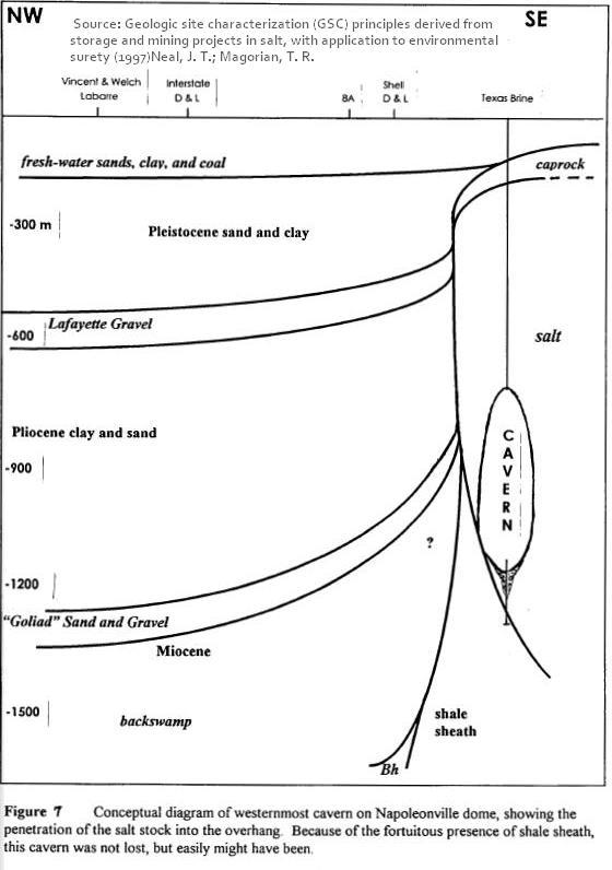
Oxy Geismar #1 is the same cavern Louisiana Dept. of Natural Resources claims was spoken of in a 1995 Sandia Labs report entitled,
Neal, J. T. and T.R. Magorian. April 1995. Geologic Site Characterization (GSC) Principles Derived from Storage and Mining Projects in Salt, With Application to Environmental Surety. SAND95-2400J. Sandia National Laboratories, Albuquerque, NM.
This report clearly speaks of a cavern laying against the shale sheath, as evidenced in the below caption:
Since LDNR claims this is Oxy Geismar #1, and that they had no knowledge of said SANDIA LABS report, then it seems logical that LDNR is accusing Sandia Labs and the two scientist’s of incompetence, for not forwarding this report to their office, for their attention, nor to the industry it involves, such as Salt Cavern Brine Mining, although fully available for any industry at all times, as well as SANDIA LABS working with all governmental authorities regarding local issues concerning the Geo Sciences.
Please LDNR, give us all a break! None are as stupid, or negligent as you claim, with the exception of yourselves, of course.
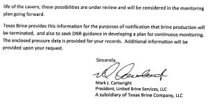
In a recent Advocate article by David Mitchell, Mark Cartwright, former President of United Brine Services LLC, a subsidiary of Texas Brine LLC, now the Vice-President of Texas Brine LLC, had this to say;
“Texas Brine’s Cartwright said that even after the 2010 study, his company had no reason “whatsoever” to believe the side wall of the cavern would collapse.
And conventional wisdom held that at those depths, about 5,000 feet, any rupture would be contained by the surrounding rock, he said.
“In fact, I think at the end of this process you’re going to see some really interesting papers written by some very smart people that will revolutionize our belief about what can happen deep,” Cartwright said.”
This is an outright lie, as when President of United Brine, Mark Cartwright was the very one that raised the alarm in the first place!
“One obvious concern is the cavern’s proximity to the edge of salt,” Cartwright wrote to DNR’s Joseph “Joe” S. Ball Jr. “There have been several studies in this regard, and Texas Brine has mapped the salt boundary near the cavern applying available well log data, seismic data, and most recently, vertical seismic data gathered during the workover. At this time, a breach out of the salt dome appears possible.”
Ball is the director of the DNR Injection and Mining Division, which oversees salt caverns.
So, United Brine’s President Mark Cartwright spills the beans in no uncertain terms, then gets kicked up the ladder afterwards, and becomes Texas Brine’s Vice-President, and says… “We didn’t have a clue.” I’ll let your own discernment be your guide to the answer.
Is this a common sense approach? Most definitely. Mere supposition at this point would be futile, and counter-productive, and I wish to avoid such interpretation, due to the copius amounts of information now available to so many.
Keep an eye towards Oxy Geismar #1, for it is another engineering disaster waiting to happen.
Coming up next;
Could there be another contributing factor to this disaster as well? Mainly the Hooker Oil Drilling Well #1, just feet away from the Oxy Geismar #3 Salt Cavern, and over a 15 year period depleting the formation at the same depths as the bottom of Oxy Geismar #3.
We shall explore these possibilities in my next article.. Louisiana Sinkhole: Comedy of Errors?
ON AUGUST 12, 2012, TEXAS BRINE SUBMITTED A PLAN THAT STATED A CONTAINMENT BERM/DITCH around the then 2.5 acre Sinkhole. Ever see that happen? At over nine acres, still a containment berm has been unable to be completed before, so why now, after untold environmental damage has been done?
All of the formation waters, hydrocarbons, TDS’s, TDC’s, etc. were allowed to contaminate the surrounding waterways, bayous, and swamps, although TEXAS BRINE proposed the first plan to contain the waters of ‘Lake Oxy 3’ to the Department of Conservation 9 days after the sinkhole formed. We are now at 221 days and counting..
At the bottom of this document is also contained a PLAT map of all OWNERS of the property, and adjacent land owners. OCCIDENTAL CHEMICAL CORP. Owns the land, and the Cavern, (OXY GEISMAR 3), and Texas Brine owns nothing but the casing and operates the well.
WHY IS THIS IMPORTANT? Because according to the recent decision of the courts, the OWNER IS RESPONSIBLE for the CAVERN, and not the on-site OPERATOR.
Below is an explanation of how DOW CHEMICAL escaped all liability for the 2003 GULF SOUTH Incident in Grand Bayou. It also serves as the basis for enjoining OCCIDENTAL CHEMICAL CORP. in any lawsuit, and force them to admit ownership.
This is why TEXAS BRINE keeps claiming they ARE NOT responsible. They are just not disclosing the whole truth, and probably never will on their own. My money is on Occidental Chemical Corp. remaining very quite, as they know they are liable and have much deeper pockets than Texas Brine and that scares them to death.
COURT CASE:
“Kirkland’s win in the Dow Chemical matter resolved a high-stakes battle between the company and a Dow lessee’s insurer, Oil Insurance Ltd., and showcased the firm’s methods.
Oil Insurance had sought in a Louisiana trial court subrogated damages from Dow related to the 2003 rupture of an underground gas storage chamber operated under lease from Dow by Gulf South Pipeline LP.
Oil Insurance alleged that Dow was liable because it had constructed the gas well improperly. Gulf South’s cleanup costs and lost profits related to the rupture, which released millions of cubic feet of gas and resulted in the evacuation of the surrounding community, amounted to more than $145 million.
Kirkland stepped in as lead counsel in 2007 on Dow’s behalf and convinced the judge to set up a phased approach, under which the firm proceeded with two attacks on the insurer’s claim that ultimately led to the case’s resolution.
The firm first used discovery to produce key admissions from the insurer’s damage expert, leading the court to scrub some $80 million in damages for a purported failure to present underlying documents.
Kirkland then successfully argued in a summary judgment motion that an additional $30 million chunk of Oil Insurance’s claims should be stricken based on a waiver of subrogation clause.
Having twice sided with Oil Insurance on the issue earlier in the case, the court, which rendered judgment last March, made new Louisiana law for the manner in which it applied the waiver of subrogation to the insurer’s claims.
Following the court’s decision, the parties settled the remaining claims, with Gulf South and Oil Insurance assuming all liability for litigation currently underway with area residents.
Additionally, Dow settled its own claims against Gulf South in a confidential settlement.
I do hope you are now getting the picture. The Courts ruled that since Gulf South was the OPERATOR and that it’s CASING FAILED, and that DOW only owned the property and the actual cavern and it didn’t fail, then GULF SOUTH and OIL INSURANCE were liable.
Applying this Court decision, then conversely, since OCCIDENTAL OWNS Cavern OXY GEISMAR 3, and TEXAS BRINE only operates the well and casing, then OCCIDENTAL CHEMICAL CORP. and it’s INSURANCE COMPANY are the actual LIABLE PARTIES, depending upon whether Texas Brine signed a similar waiver of subrogation.
Also, Texas Brine, because of the 2010 mill out at 2380 ft.-2480 ft., without reliable knowledge from the VSP (performed later the same year), but having Sonar surveys of the Cavern showing the straight line deformation of the shale sheath pressing against the cavern’s bottom 1000 ft., suggesting that not enough salt existed for such a mill out test, and is therefore are liable for this portion of the cavern’s failure.
I know this doesn’t help unless taking on litigation, but it is valuable information in your fight to get relief. Please speak with your Attorneys to check out these important matters, and it’s implications in enjoining Occidental Chemical Corporation as Defendant, with Texas Brine, LLC.
(DISCLAIMER: I am not an attorney and my opinions should not be construed as such. Please consult your own attorney for specifics on the value of the information contained within this article.)
Unfortuately, this sensationalised story took the center stage and prevented a much greater understanding of the actual issues at hand. Many speakers gave presentations, and for once the residents of Bayou Corne got far more answers than they were prepared to handle.
Residents were literally diluged with information that took most off-guard, and having to view the videos to get even half the information that was imparted to them. This is truly understandable, considering the months of stone-walling, and jibber-jabber with no real answers. This is not the case now.
Finally an understanding of the Bayou Corne ‘Sinkhole’ may be at hand. Instead of boring you with a run down of each and every presentation right off the bat, let’s just introduce the Presenters, or their affiliations, and their results in a quick nutshell.
First, we had Shaw and the Louisiana Office of Conservation that hired petroleum geophysicist Don Marlin to interpret three-dimensional seismic data that Texas Brine Co. LLC is planning to collect around the sinkhole.
According to the 2007 ‘proprietary 3-D survey’ obtained from Golden Gate Petroleum, the small .3 mile survey was presented as thus:
According to Mr. Marlin, blah, blah, blah. (I can do this, no one can fire me from my own blog) <This view is from the West, as if you were looking at it from Bayou Corne>
(Warning! Author’s informed interpretation and rant follows)
Truth is, this 3-D Survey reveals some very telling details. Although not definitive, it seems the working theory is this: Texas Brine milled out a section around 2350 ft. right on a major fault section closest to the casing, not considering they had very little salt to work with there. The salt is either washed away and damaging the shale formations close to the fault line, or overpumped freshwater in the millout to have accomplished the same thing.
(Start at the 5 Min. mark if it does not go there)
Here, Mr. Gary Hecox admits the geologists of the time thought the salt extended out another 1,000 ft. in 1982, yet fails to mention the voluminous records of SONAR surveys, (latest was 1997), or the Vertical Seismic Profile in 2010, which definitvely showed the cavern laying upon the shale sheath.
(Additionally a lower, lesser fault line is shown and not identified as such further north and under the sinkhole, running along the blade of the knife-looking structure in the graphic.)
This gave the fault the impetus to become active, (meaning fracturing the fault line rock formations), until over a matter of a year and a half; the fault grows bigger as does the mini-quakes, fracturing more rock as it grew, until it essentially shook the shale sheath, (upwards and downwards equally), to pieces and caused the cave in, which in turn took out the remaining shale sheath at depth and cracked the cavern portion that was known to be laying entirely on the shale rock sheath, and this caused the frack out.
This reached to a depth of about 6000 ft. since the overburden pressures caused a momentary pressure of over 7,000 psi. It was a mighty geological explosion, as evidenced by it clearing a path to the surface, and the sinkhole culminating outside the salt dome. Most sinkholes have occured over the top of salt domes, so this is truly a geological first, and at the same level of the oil, gas, and water formations that were pressuring the shale sheath from the west side. A fact known since 2007 by LDNR, Texas Brine, and by the owner of the property, Occidental Chemical Corp.
This information should have been known months ago. The 3 D survey would have shown it just as well then, if not for Golden Gates ‘Proprietary’ legalese. In an emergency situation, nothing should be held up for months over ‘proprietary’ concerns.
Also looking at the depth of the hydrocarbon formations, then there are many culprits at varying depths, but since Oxy 3A is still producing hydrocarbons, then we do know it is at depths greater than 3700 ft. in that area. What is not known is essentially whether the uppermost formation is feeding the sinkhole or not..
(DISCLAIMER: End of Author’s interpretation and rant. This is not to be construed as what Mr. Marlin actually stated, but the inference thereof)
Actually Mr. Marlin was a fount of information, as he informs the audience of the 3-D survey showing a depleted hydrocarbon formation that was drilled into and produced for 15 years, (UPDATE BELOW VIDEO), but the wellbore to this depleted formation is very apparent and clear. Also near the end of his presentation, he is able to describe the salt wall almost to a tee, as it was in 2007. Valuable information indeed. Please watch this short video, as it lends much to the reader’s understanding of the geology of the region.
UPDATE:
Upon further investigation, this tells a very sordid story of Hooker #1 Oil Well. A drama in and of itself.
The well was first drilled and completed in 1986 and was a 6300 ft. borehole down to the depleted formation shown in the 2007 3-D survey.
It changed hands a few times until Energy Self Service Oils, Baton Rouge, La. took it over in 2006, then sometime between then and Feb. 2009, just up and walked off.
Orphaned without a word to anyone. The state had to come in and P&A the well themselves in 5/12/2010. This was an open well, a fire hazard on the surface and right next door to the Oxy #3 cavern and at the same depths, Unreal.
This depletion of this formation right next door to Oxy 3 and the salt dome may have had a role to play in all of this. Just absolutely mind-blowing the level of irresponsibility, and a “I don’t give a damn,” attitude.
The next Presenter was ITASCA, and Dr. Pettitt, who explains the rock fracture zone that is building up gases until they overwhelm the fractured rock voids and released in the ‘burps’, and then sucks back down water. He cannot actually explain the process, as it is unique in the world of geology. He also admits not knowing the size, nor shape of the ‘disturbed rock zone’ nor what effects it may be having upon the Salt Dome wall.
Although ominous, so far the closest cavern (Oxy #2) is holding it’s integrity, and while the diesel blanket was being replaced to protect the top of the Oxy #2 cavern ceiling on January 19th, no activity was recorded in the cavern during these two seismic events. Although only 370 ft. east, it seems that Oxy #2 showed no signs at all of losing integrity. Good news indeed.
He also explains in detail the seismic readings, which I won’t go into here, but if interested, watch Part 10 at Assumptionla You Tube page:
Next up, was Dr. Gary Hecox, and we have already touched upon what he had to say, but he did give a grim report to the residents regarding gas vent wells in the community. Many of these wells and the intendant piping may well become a permanent fixture, yet he did hold out some hope that the new 3-D seismic survey will identify the formation responsible for the methane gas, and that if so, a well could be drilled to depth and release the pressures long before they reach the aquifer or the resident’s community.
Once again, and pulling no punches, Mr. Hecox stated that all the Bayou Corne homes should be evacuated. The Evacuation Order was appropriate. This should be latched onto by the media and residents, and put forth to Texas Brine and Occidental Chemical Corporation, as well as Louisiana Dept. of Natural Resources to provide the necessary funds to accomplish this objective and buy-outs made available to those that wish to do move on with their lives.
In a very shocking statement, Mr. Hecox admits, they all were in error by trusting the PDK logs to detect gas in the larger water well’s casings and multiple casings, (PDK: An electronic neutron generator in the tool produces pulses of neutrons which spread into the borehole and formation.)
Now, the spread and extent of the methane gas eastwards is in question, and another tool to detect the gas must be found. This is an astounding admission, and Mr. Hecox should be thanked for his honesty and integrity, to be able to admit his own limitations. To address this new issue, a Dr. Charles Faust of Tetra-Tech, is being brought in to develop a better gas mitigation model. This seems apropo in this ‘Faustian environment’.
Also disclosed, and as reported by this blog, two events actually happened on January 19th, 2013. While officials at the time claimed the seismic activity immediately abated after the ten a.m. event that displaced 15,000 cubic feet of water down the sinkhole funnel and into the unknown voids below, but also that there was a second six p.m. event that was much larger and displaced over 40,000 cubic feet of water for a total of 55,000 cubic feet of water that was sucked under the earth as methane gas escaped to the surface, presumably an equal amount, yet that would be inaccurate as it seems the Mississippi River Alluvial Aquifer sands and gravel broke up the gas bubble and diluted it among the aquifer itself, and shunting the most part of the methane under the community and subdivision itself, via the aquifer. How far east is still unanswered.
This is pretty much a run down of the whole meeting, except for resident’s questions, and they are very important questions that I would highly recommend that you watch.
That being said, the residents were very inquisitive about the new gas wells going into the subdivision, and were pretty vocal about it. To the point that Mr. Hecox was struck speechless twice. Several voiced they did not want them in their front or backyards, and if they affected an area 500ft. square, then put them at the land boundries.
Finally one resident, who was very bright, suggested the usage of Four wells out in the swamps and using a steerable bore drill to alleviate the pressures without all the mini wells and piping. It is a non-invasive solution. It is one that Oxy and TB will not want to pay for, but the issue can be forced if no one signs the releases and allows all the tiny wells to go in. However, this will not stop Texas Brine from drilling at all the land boundries, and ignoring the resident’s wishes, while looking and pressuring for that one or two, that will allow vent wells in the middle of the subdivision. That would negate the need for Horizontal Wells, and completely ignore resident’s concerns. As we all know, that seems to be Texas Brine’s style.
Yet, If the Resident’s calmly state their case and even in writing, explaining that the technology Dr. Hecox stated in this video is available and that this non-invasive method is best. Horizontal relief wells are available, but they won’t be, if the residents sign away their rights and Texas Brine, Occidental Chemical Corp. and LDNR’s liability.
There was good news, and bad news, but for the first time, we all have some news.
It has come to my attention that some of the local resident’s of Bayou Corne are angry with many of us “Dry-Landers” not understanding what it means to live in a ‘bayou”.
One such sentiment is, “The beef the locals have with us cyber visitors is they say the Lake OXY 3 was there all along. Just covered in floating grass. And as part of the oil skimming deal they take up the grass exposing black oily water. But it is not new water they say. So they say sinkhole isn’t expanding. We are just seeing more swamp due to grass removal and tree die off.
They are getting peeved that we don’t get their view point.”
My response is this… a bayou is defined as, “a marshy arm, inlet, or outlet of a lake, river, etc., usually sluggish or stagnant. or any of various other often boggy and slow-moving or still bodies of water.”
Also I have been in the swamps many times over the last 35 years with friends all over Louisiana, so I do have a clue as well.
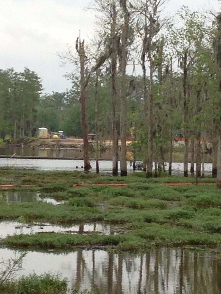
But I have never been in any swamp or bayou that is 145 ft. deep. That is more of a lake, and so is the reason I named that small area, “Lake Oxy 3”.
This in no way implies that there wasn’t water in a bayou to begin with, as that would be silly, but since the subsidence, (or slough off as Texas Brine and DNLR are calling it as well as slurry), the natural fresh (fresh is a stretch I know, but even stagnant is considered fresh), waters and evidently brine have co-mingled to create “Lake Oxy 3” and I named it that to remind everyone of Texas Brine and it’s customer Oxy, or Occidental.
Nor have many been claiming that the actual tear in the earth is getting larger, because we can’t see it any better than ya’ll can, so we rely on the updates just as ya’ll do.
What most of us, and LDNR are so concerned about is the rising waters. It is that time of year when the waters rise, which of course then intersects with all other surrounding waterways, canals and bayous, thereby carrying all of the crap rising out of the sinkhole, cave-in, whatever you want to call it to your back doors. The rise in the salinity of the surrounding waters is a major concern but even more alarming is the hydrocarbons that Texas Brine just got fined for not containing properly.
These are our concerns as well. Is this what you folks want to be surrounded by? As the waters of Lake Oxy 3 rise, so too shall all of the environmental and human damages also begin to rise. Even the Police Jury seems to understand as evidenced by their last statement;
“A resolution was approved requesting that Texas Brine consider providing the option of a buyout or relocation to the residents of Bayou Corne.” and ” A resolution was approved to object to any and all extensions, contingencies, or modifications to the orders invoked by the Department of Natural Resources onto Texas Brine specific to the sinkhole.”
As per the all of the above reasons, I urge all of you still in Bayou Corne to heed the Jury’s resolution. I hate letting the oil and brine and natural gas people win, and I truly believe they should be forced to pay double for all properties and relocation, but this is truly a lost cause. There is no way for Texas Brine or anyone else that will be able to contain the TPH’s, the chloride’s or the TDS’s once the waters reach that magical level when this is no longer a highly localized matter, but an area wide contamination.
So forgive all of us “Dry-Landers” for not showing more compassion and understanding when we report on just Texas Brine and LDNR, such as;
Then to hear that your neighbors over in Doyline are dealing with their own explosive crisis.
“Weather could complicate the transfer of roughly 6 million pounds of explosives that were haphazardly stored at an industrial site in northwestern Louisiana and led to the evacuation of a small town, a state police spokeswoman said Monday.” is just beyond belief and heart breaking.
Forgive us for our ignorance, but please understand our passion for getting the right thing done, and whether you know it or not, doing the right thing by all of ya’ll as well.
As Kenny Rogers said in his song, “Sometimes…you have to know when to hold ’em, know when to fold ’em.”
Ultimately, that choice is up to you, the people whom live in a paradise turned nightmare.
LOUISIANA DNR COMPLICIT IN SINKHOLE COVERUP AND MISINFORMATION!
by: FREEDOMROX
As most know, I normally do not concern myself with anything other than the larger picture. As a researcher, it is far more likely that I tie together what others do not and in ways that seem a little extreme…that is, until proven correct. “Always let Occam’s Razor be your guide”, was one of the first lessons I ever learned…after “Always eat your vegetables, whether you like it or not!”
But sometimes, you come across something so reprehensible that you must bring yourself down to earth and just report the little things, and allow the chips to fall where they may. Such is my task at this time.
Regarding the Louisiana Sinkhole in Bayou Corne, Assumption Parish, La., there has come to my attention a most corrupt and sickening amount of data that leads me to an inevitable conclusion.
The Louisiana Department of Natural Resources, (DNR), has been complicit in a coverup, and in attempting to hide it’s own culpability in the disasterous results of its own actions, and the catastrophic consequences visited upon the people of Louisiana, especially those of Grand Bayou, (again), and Bayou Corne, as well as anyone else whom may be affected in the future by this Department’s negligence.
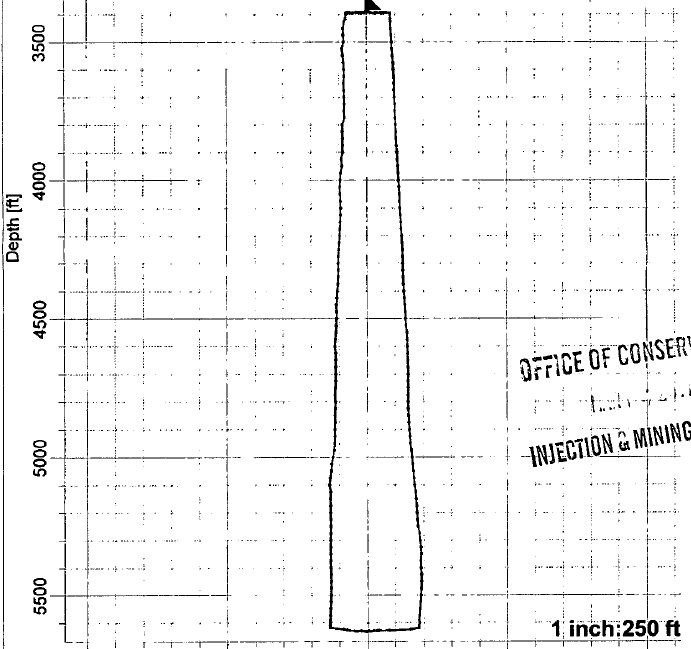
When asked for details of the Texas Brine Oxy Geismar #3 cavern size and dimensions, we get all kinds of answers. It’s about the height of two Empire State Buildings, or it is approximately….. but never a straight answer. Only once have we obtained anything near a straight answer, but that was reported by the Advocate, to wit;
“The cavern roof is at 3,400 feet underground, and the cavern extends down to 5,650 feet. The roof is 150 feet across. Its base is 310 feet across.”
That is 2, 250 ft. in height of storage space with a base of 310 ft. across at the bottom, but according to what few diagrams we get, narrower at the top at 150 ft. About 205 ft. mean width. But we do find in the August 13, 2012 permit issued to Texas Brine, LLC from the LDNR, that the top of the Salt Cavern is at approximately 3400 ft. below the surface of the earth. Whew! Glad that is sorted out. Also, from the Advocate we know that the bottom of the cavern is at 5,650 feet, right?
Wrong!
Add the above and you will come up with 4, 850 ft. of piping, that is further away from the original borehole, but this equates roughly to the top of the dome being at 3450-3500 ft. So it seems we are good here. Look Below for the Operational Plan of Oxy Geismar Well #3A.
It seems that LDNR and Texas Brine knows that the bottom is at 4241 ft. and not 5,650 feet now, (a loss of 1409 ft.), and either something is pushing up the bottom of the Salt Cavern, or is compromised by an outside influence, and have reported it in their documents, so please don’t jump the gun.
“Assumption Parish President Mike Waguespack stated, “We knew when they got into the cavern that the bottom had been compromised.”
Of course we all know from the west side it is in the collapsed zone with voids, but there is an unknown force upon the east side as well. But they will not say what, exactly, is the source. Why? Because it is METHANE AND OIL MIGRATION. Why would they not tell us this simple fact? Because it means that everyone involved is LIABLE! PERIOD. EVERYONE!
As everyone knows if they have read my articles that I believe there is a Methane Migration Zone stemming from the April 20, 2010 BP Well Blow Out in the Gulf of Mexico, and I still do believe that it is a firm motivator and engine of destruction in this ongoing saga, but other more local factors exist as well.
But…. It is a well known and established fact that Methane Migration is a REALITY. Allow me to prove this assertion, please.
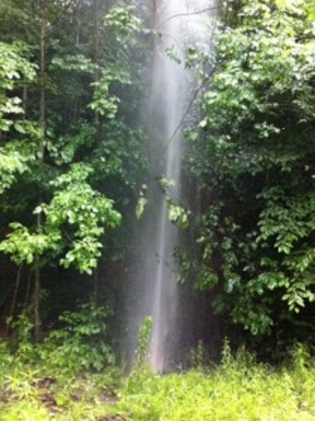
Nearly a year later, Bradford County resident Michael Leighton is worried about the flammable gas seeping into his woods.
Leighton lives about a half-mile from a Chesapeake Energy well that Pennsylvania’s Department of Environmental Protection suspects leaked methane gas through holes in its casing. For more than two months, gas has been gurgling into creeks and wetlands on Leighton’s property. That’s in addition to the methane in Leighton’s water well, and the methane in his basement.”
This story goes on to report about a Methane Geyser; “Soon, someone discovered a bigger problem: a geyser shooting methane-infused water more than 30 feet in the air. “That’s when all hell broke lose,” said a neighboring landowner — who, like others State Impact Pennsylvania talked to about the Union Township problems, requested anonymity, due to ongoing negotiations with Shell over damages and leasing.”
Video of alleged Methane Geyser in N. Pa.
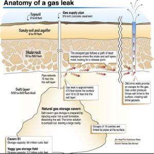
As if in the grip of a real life disaster movie, the town of Hutchinson, Kansas experienced its own “gas migration”,
The gas crisis that rocked Hutchinson, Kansas
“A geyser erupted on Hutchinson’s east side. The nearby railroad was shut down. And a sink hole appeared.
Authorities posted barricades on streets, sealing off an evacuated downtown. Shelter preparations began at the Kansas State Fairgrounds.
In a rat-a-tat sequence, those events shook Hutchinson between 10:45 a.m. and 4:30 p.m. on Jan. 17, 2001.
They were only the start. Tragedy visited the next day.”
“Old brine wells, the legacy of salt-solution mining, dotted Hutchinson, including one beneath the Hahn home. Gas was rising up through those wells, so authorities combed records at the Reno County Historical Society and Hutchinson Public Library to determine the location of old salt plants and wells.”
“Ratigan at first was skeptical that gas migrating from Yaggy Field was causing eruptions in Hutchinson, but soon became convinced that was the cause.
ONEOK would acknowledge later that approximately 143 billion cubic feet of gas escaped from a leak in the S-1 cavern.”
Please read the whole story at the link provided to understand the true scope of the disaster.
Anatomy of A Salt Dome Methane Release in Hutchinson, Kansas
These two stories are only a minor sampling of the proof of Methane Gas Migrations, and an excellent reason for obfuscation of the true issues in Assumption Parish.
That, however does not in any way excuse the manipulation of information that was to come next by the DNR in Louisiana.
In a federal lawsuit filed in New Orleans on August 13, 2012, alleged that, “a salt cavern failed, which Texas Brine Co. was using to store radioactive material, a byproduct of the drilling industry.
The class claims that Texas Brine knew the cavern walls were liable to breach as early as January 2011, but failed to warn the public.
“The public was not warned in January 2011 or any time thereafter or prior of the potential danger resulting from the failure of this cavern and the general public had no knowledge of the storage of the radioactive material in the cavern,” the complaint states.”
“In early September 2010, defendant began reworking the cavern well, milling a section of salt higher than the existing cavern roof, at 3,400 feet deep, to see if the upper strata could be mined. This area extends for about 100 feet through the well casing above the cavern roof.
“On January 21, 2011, Mark J. Cartwright, President of Texas Brine Co. Saltville informed the Louisiana Department of Natural Resources (LDNR), via letter, about a failed integrity test of the cavern and suspicion that the cavern may have breached the Napoleonville Dome’s outer wall. These problems with the cavern led to the cavern being plugged in June 2011. The area milled in September 2010 may be the source of the salt dome breach.
“LDNR records show that Defendant had been examining the cavern’s wall at least since June 2010.”
(ASIDE) Why on earth would Texas Brine try to brine the roof of the Salt Cavern? It is stated as a fact that the top of the Cavern is at 3400 ft., so why try to mine at less than 1200 ft. above this level? Common sense should have overidden greed in this case, and the DNR knew it as well!
Up until present day, any news story even approaching this subject was given a 20 ft. of Naturally Occurring Radioactive Material, (NORM), was deposited in the Texas Brine Oxy# 3 Salt Cavern in 1995. This is not true at all, and DNR knows it isn’t.
As stated, the document does not say 20 ft. of NORM, but 20 ft. cubed which is about a cubic yard of NORM contaminated material, and even this seems to be a lie as well, since all fracked materials are considered Technologically-Enhanced-Natural-Occurring-Radioactive-Materials, (TENORM) http://www.epa.gov/rpdweb00/tenorm/
Evidence exists that Texas Brine has been putting this amount back into three different salt caverns since 1994. Not just at Napoleonville either. They own three other mines at Bayou Choctaw as well, and got permission to use these caverns as ‘Dual Usage’ Caverns as well.
Dual Usage means brining for salt, and then depositing radioactive shale created from brine solution mining bak into the same well to settle on the bottom..
Is this enough proof for a court of law to litigate? I truly believe so, and the evidence just keeps on piling up, and none in favor of LDNR. They have shown at the least that they obfuscate, prevaricate, and even outright lie, to protect their cash infusions from oil-soaked petro dollars contributed by Super-Corporations that dominate the area as well as the Gulf of Mexico entire.
Maybe it is time to investigate the finances of these Corporate Cronies, Elected State Officials, as well as the Elected Representatives of these Districts to see just where they may have received financial favor and campaign contributions… That is covered under the PATRIOT ACT isn’t it? If not, then surely State and Federal RICO laws apply?
The truth of the matter is, that as far as any of us are allowed to know, is that Grand Gulf Energy, and Golden Gate, Inc. and its unnamed 60 percent partner, is the only drilling operation that could allow such a migration of Methane and Oil.
We should all be looking for who else was drilling prior to these interests, and before the sinkhole developed, if any. Otherwise, we have a culprit on the hook.
As Linda Cooke states over three months ago;
“I was told the more correct term was investigatory well, or a well which would be drilled down to the suspect brine cavern so investigating what might be going on could be done. And it was 3,400 feet just to the top of the brine cavern! I had no idea it was that far down.
As I understand it, this “relief” well will be drilled starting late this week, and I don’t know how long it will take to get down that far. Nor what will happen when they get there. It will be interesting.
I have some friends who have evacuated their home in Bayou Corne and are now living in their RV a few miles away. The husband recently had five heart bypasses, and they’re not too happy about the whole situation.”
I have so much more that I can share, but this article is too long as it is. I will wait with baited breath to see how many pick up on this most important addition to the ongoing soap opera known as, “As the Bayou Churns”


